IMAGES TAKEN NEAR TO
Wix Hill, LEATHERHEAD, KT24 6ED
Introduction
This page details the photographs taken nearby to Wix Hill, KT24 6ED by members of the Geograph project.
The Geograph project started in 2005 with the aim of publishing, organising and preserving representative images for every square kilometre of Great Britain, Ireland and the Isle of Man.

There are currently over 7.5m images from over14,400 individuals and you can help contribute to the project by visiting https://www.geograph.org.uk
Image Map
Images are licensed for reuse under creativecommons.org/licenses/by-sa/2.0
Notes
- Clicking on the map will re-center to the selected point.
- The higher the marker number, the further away the image location is from the centre of the postcode.
Image Listing (22 Images Found)
Images are licensed for reuse under creativecommons.org/licenses/by-sa/2.0
Image
Details
Distance
2
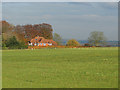
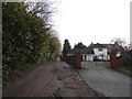
Wix Hill House
Wix Hill House from the bridleway from Blake's Lane.
Image: © Alan Hunt
Taken: 18 Nov 2014
0.14 miles
3
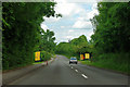
Yellow signs on Epsom Road
The temporary signs warn that on 28 and 29 July the road will be a no stopping tow away zone, and moreover the road will be closed anyway. This is because of the Olympic cycle road races.
Image: © Robin Webster
Taken: 18 Jun 2012
0.16 miles


7
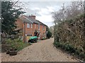
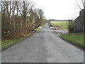
Victorian Red Brick cottage with Developments
Nicely upgraded access road to a few properties.
Image: © James Emmans
Taken: 13 Jan 2019
0.20 miles
8
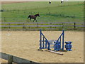
Paddocks by Woolgars Farm
Grassy fields and a sandy arena by Woolgars Farm, near East Clandon. Horses are to be found in many of the fields around here.
Image: © Colin Smith
Taken: 3 Aug 2008
0.20 miles
10
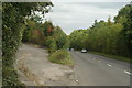
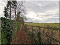
A246 at West Horsley, Surrey
The old A246 lies to the left. Some time during the 1960's, the "new" road to the right was built.
Image: © Peter Trimming
Taken: 17 Sep 2009
0.20 miles