IMAGES TAKEN NEAR TO
Guildford Road, LEATHERHEAD, KT24 5RY
Introduction
This page details the photographs taken nearby to Guildford Road, KT24 5RY by members of the Geograph project.
The Geograph project started in 2005 with the aim of publishing, organising and preserving representative images for every square kilometre of Great Britain, Ireland and the Isle of Man.

There are currently over 7.5m images from over14,400 individuals and you can help contribute to the project by visiting https://www.geograph.org.uk
Image Map
Images are licensed for reuse under creativecommons.org/licenses/by-sa/2.0
Notes
- Clicking on the map will re-center to the selected point.
- The higher the marker number, the further away the image location is from the centre of the postcode.
Image Listing (4 Images Found)
Images are licensed for reuse under creativecommons.org/licenses/by-sa/2.0
Image
Details
Distance

2

Old Well, East Horsley
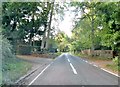
At the corner of Guildford Road and Park Horsley is this typical Surrey well. It no longer works but it sits below a tiled roof and has benches around it. Guildford Road, looking east, is behind the well.
Image: © Colin Smith
Taken: 19 May 2007
0.09 miles
4
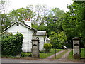
Lodge Gate near Effingham
Entrance to Effingham Lodge, south-west of the village. The gate has a metal arch with lamp.
Image: © Colin Smith
Taken: 19 May 2007
0.22 miles