IMAGES TAKEN NEAR TO
Green Dene, LEATHERHEAD, KT24 5RQ
Introduction
This page details the photographs taken nearby to Green Dene, KT24 5RQ by members of the Geograph project.
The Geograph project started in 2005 with the aim of publishing, organising and preserving representative images for every square kilometre of Great Britain, Ireland and the Isle of Man.

There are currently over 7.5m images from over14,400 individuals and you can help contribute to the project by visiting https://www.geograph.org.uk
Image Map
Images are licensed for reuse under creativecommons.org/licenses/by-sa/2.0
Notes
- Clicking on the map will re-center to the selected point.
- The higher the marker number, the further away the image location is from the centre of the postcode.
Image Listing (5 Images Found)
Images are licensed for reuse under creativecommons.org/licenses/by-sa/2.0
Image
Details
Distance
2
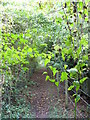
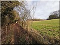
Old London Lane
Former drove road and forestry track in the North Downs south of East Horsley. It is fenced on both sides today.
Image: © Colin Smith
Taken: 13 Oct 2007
0.13 miles
4
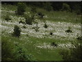
Hillside by Stony Dene
Drifts of white campion on the grassy hillside south of Horsley.
Image: © Colin Smith
Taken: 10 Jun 2012
0.20 miles
