IMAGES TAKEN NEAR TO
Guildford Road, LEATHERHEAD, KT24 5QD
Introduction
This page details the photographs taken nearby to Guildford Road, KT24 5QD by members of the Geograph project.
The Geograph project started in 2005 with the aim of publishing, organising and preserving representative images for every square kilometre of Great Britain, Ireland and the Isle of Man.

There are currently over 7.5m images from over14,400 individuals and you can help contribute to the project by visiting https://www.geograph.org.uk
Image Map
Images are licensed for reuse under creativecommons.org/licenses/by-sa/2.0
Notes
- Clicking on the map will re-center to the selected point.
- The higher the marker number, the further away the image location is from the centre of the postcode.
Image Listing (8 Images Found)
Images are licensed for reuse under creativecommons.org/licenses/by-sa/2.0
Image
Details
Distance
1
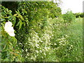
Bridleway near Effingham
This was very overgrown. Dog roses, nettles, trees, bracken, grasses, etc, etc spread over the track.
Image: © Colin Smith
Taken: 19 May 2007
0.11 miles
2
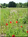
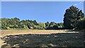
Set-aside Field, Effingham
One of several fields not currently being cultivated.
Image: © Colin Smith
Taken: 19 May 2007
0.15 miles
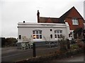
7
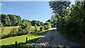
Salmons Road
A narrow access road to a few rural properties.
Image: © James Emmans
Taken: 16 Jul 2021
0.24 miles
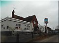
8
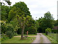
Salmons Road
Rural loose-surfaced road south-west of Effingham. Note the flower-pot man and plough behind the tree!
Image: © Colin Smith
Taken: 19 May 2007
0.24 miles