IMAGES TAKEN NEAR TO
Norrels Drive, LEATHERHEAD, KT24 5DL
Introduction
This page details the photographs taken nearby to Norrels Drive, KT24 5DL by members of the Geograph project.
The Geograph project started in 2005 with the aim of publishing, organising and preserving representative images for every square kilometre of Great Britain, Ireland and the Isle of Man.

There are currently over 7.5m images from over14,400 individuals and you can help contribute to the project by visiting https://www.geograph.org.uk
Image Map
Images are licensed for reuse under creativecommons.org/licenses/by-sa/2.0
Notes
- Clicking on the map will re-center to the selected point.
- The higher the marker number, the further away the image location is from the centre of the postcode.
Image Listing (4 Images Found)
Images are licensed for reuse under creativecommons.org/licenses/by-sa/2.0
Image
Details
Distance
1
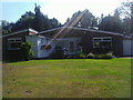
Modern house on Norrels Drive, East Horsley
Image: © David Howard
Taken: 16 Aug 2010
0.09 miles
2
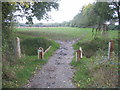
Old London Road and Effingham Common
This track was obviously once a more significant thoroughfare. The bridge also provides access to Effingham Common. This is a Registered Common with open grassland, mixed broadleaf ancient semi-natural woodland; predominantly oak, improved pasture, arable land and ponds; the total area is 32 hectares.
Image: © Pip Rolls
Taken: 21 Oct 2005
0.13 miles
3
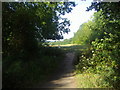
Field entrance on Heath View, East Horsley
Image: © David Howard
Taken: 16 Aug 2010
0.16 miles
4
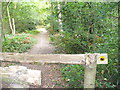
Footpath into Greatlee Wood
Riders are encouraged to stay on Old London Lane and to keep out of this Woodland Trust-administered area by these double barred gates. Horsley Jubilee Trail uses the path through the deciduous wood.
Image: © Colin Smith
Taken: 23 Sep 2007
0.24 miles