IMAGES TAKEN NEAR TO
High Park Avenue, LEATHERHEAD, KT24 5DB
Introduction
This page details the photographs taken nearby to High Park Avenue, KT24 5DB by members of the Geograph project.
The Geograph project started in 2005 with the aim of publishing, organising and preserving representative images for every square kilometre of Great Britain, Ireland and the Isle of Man.

There are currently over 7.5m images from over14,400 individuals and you can help contribute to the project by visiting https://www.geograph.org.uk
Image Map
Images are licensed for reuse under creativecommons.org/licenses/by-sa/2.0
Notes
- Clicking on the map will re-center to the selected point.
- The higher the marker number, the further away the image location is from the centre of the postcode.
Image Listing (6 Images Found)
Images are licensed for reuse under creativecommons.org/licenses/by-sa/2.0
Image
Details
Distance
1
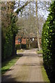
Looking along Woodland Close to house
Woodland Close is a public footpath.
Image: © Shazz
Taken: 12 Mar 2015
0.16 miles
2
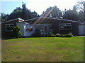
Modern house on Norrels Drive, East Horsley
Image: © David Howard
Taken: 16 Aug 2010
0.20 miles
3
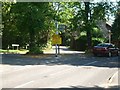
Junction of Forest Road (left) and Pennymead Drive (centre) with South Ockham Road
Image: © Andrew Longton
Taken: 8 Sep 2005
0.20 miles
4
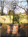
East Horsley
Ornate wrought iron sign depicting a horse. It is set upon a brick and flint base in the fork between Forest Road and Ockham Road South.
http://www.british-history.ac.uk/report.aspx?compid=42982
Image: © Colin Smith
Taken: 10 Dec 2011
0.23 miles
5
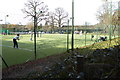
Anyone for tennis?
This is the first game I've seen this year.
Image: © Shazz
Taken: 12 Mar 2015
0.23 miles
6
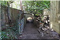
Unusual junction of paths
Ahead is a bridleway going under a private drive. The steps on the right with an immediate left turn are on a public footpath.
Image: © Shazz
Taken: 12 Mar 2015
0.24 miles