IMAGES TAKEN NEAR TO
Howard Road, LEATHERHEAD, KT23 4PW
Introduction
This page details the photographs taken nearby to Howard Road, KT23 4PW by members of the Geograph project.
The Geograph project started in 2005 with the aim of publishing, organising and preserving representative images for every square kilometre of Great Britain, Ireland and the Isle of Man.

There are currently over 7.5m images from over14,400 individuals and you can help contribute to the project by visiting https://www.geograph.org.uk
Image Map
Images are licensed for reuse under creativecommons.org/licenses/by-sa/2.0
Notes
- Clicking on the map will re-center to the selected point.
- The higher the marker number, the further away the image location is from the centre of the postcode.
Image Listing (17 Images Found)
Images are licensed for reuse under creativecommons.org/licenses/by-sa/2.0
Image
Details
Distance
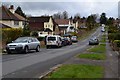
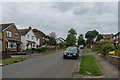
2
Dawnay Road
Housing on the southern edge of Great Bookham.
Image: © Ian Capper
Taken: 21 Apr 2017
0.09 miles
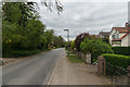
3
Dawnay Road
Housing on the southern edge of Great Bookham.
Image: © Ian Capper
Taken: 21 Apr 2017
0.10 miles
4
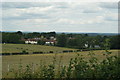
View From Fetcham Downs
Looking across to Great Bookham.
Image: © Peter Trimming
Taken: 10 Jul 2009
0.11 miles
5

Bowling Club, Great Bookham
A summer bowling match at Bookham Bowling Club
Image: © james ferguson
Taken: 23 Aug 2006
0.11 miles
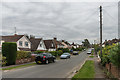
6
Dawnay Road
Housing on the southern edge of Great Bookham.
Image: © Ian Capper
Taken: 21 Apr 2017
0.11 miles
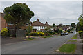
7
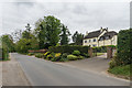
Dorking Road
Housing on the southern edge of Great Bookham.
Image: © Ian Capper
Taken: 21 Apr 2017
0.12 miles
8
Dorking Road
Housing on the southern edge of Great Bookham.
Image: © Ian Capper
Taken: 21 Apr 2017
0.12 miles
9
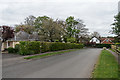
Dowlans Road
Housing on the southern edge of Great Bookham.
Image: © Ian Capper
Taken: 21 Apr 2017
0.12 miles
10
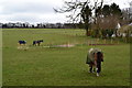
Horses in field south of Great Bookham
Image: © David Martin
Taken: 3 Apr 2015
0.13 miles