IMAGES TAKEN NEAR TO
Dowlans Road, LEATHERHEAD, KT23 4LF
Introduction
This page details the photographs taken nearby to Dowlans Road, KT23 4LF by members of the Geograph project.
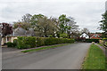
The Geograph project started in 2005 with the aim of publishing, organising and preserving representative images for every square kilometre of Great Britain, Ireland and the Isle of Man.

There are currently over 7.5m images from over14,400 individuals and you can help contribute to the project by visiting https://www.geograph.org.uk
Image Map
Images are licensed for reuse under creativecommons.org/licenses/by-sa/2.0
Notes
- Clicking on the map will re-center to the selected point.
- The higher the marker number, the further away the image location is from the centre of the postcode.
Image Listing (12 Images Found)
Images are licensed for reuse under creativecommons.org/licenses/by-sa/2.0
Image
Details
Distance
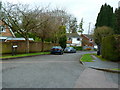
2
Beales Road
The concrete road has a thin tarmac surface, but Overton Way to the left ahead remains bare concrete.
Image: © Robin Webster
Taken: 12 Nov 2011
0.15 miles
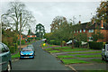
4
Dorking Road
Housing on the southern edge of Great Bookham.
Image: © Ian Capper
Taken: 21 Apr 2017
0.19 miles
5
Dowlans Road
Housing on the southern edge of Great Bookham.
Image: © Ian Capper
Taken: 21 Apr 2017
0.19 miles
6
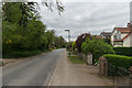
Dorking Road
Housing on the southern edge of Great Bookham.
Image: © Ian Capper
Taken: 21 Apr 2017
0.19 miles
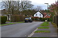
7
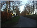
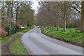
Dorking Road, Bookham
By the Bookham Riding Centre on the left
Image: © David Howard
Taken: 16 Jan 2012
0.19 miles
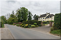
8
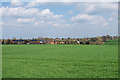
The edge of Great Bookham
Houses in Downlans Road and Groveside and their associated cul-de-sacs on the edge of Great Bookham, seen over farmland north of Goldstone Farm.
Image: © Ian Capper
Taken: 14 Apr 2018
0.20 miles
10
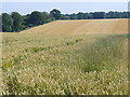
Wheat Field by Goldstone Farm
Ripening grain crop north-east of the Downland Goldstone Farm.
Image: © Colin Smith
Taken: 26 Jul 2008
0.23 miles