IMAGES TAKEN NEAR TO
Atwood, LEATHERHEAD, KT23 3BH
Introduction
This page details the photographs taken nearby to Atwood, KT23 3BH by members of the Geograph project.
The Geograph project started in 2005 with the aim of publishing, organising and preserving representative images for every square kilometre of Great Britain, Ireland and the Isle of Man.

There are currently over 7.5m images from over14,400 individuals and you can help contribute to the project by visiting https://www.geograph.org.uk
Image Map
Images are licensed for reuse under creativecommons.org/licenses/by-sa/2.0
Notes
- Clicking on the map will re-center to the selected point.
- The higher the marker number, the further away the image location is from the centre of the postcode.
Image Listing (6 Images Found)
Images are licensed for reuse under creativecommons.org/licenses/by-sa/2.0
Image
Details
Distance
1
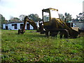
Long Maddox Farm
Digger and stable block on the western edge of Little Bookham.
Image: © Colin Smith
Taken: 14 Oct 2007
0.13 miles
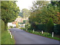
2
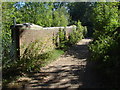
Maddox Lane
The railway bridge on Maddox Lane.
Image: © Alan Hunt
Taken: 7 Sep 2012
0.14 miles
3
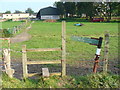
Stile at Long Maddox Farm
The footpath to Bookham takes sharp right-angled turns as it goes past the farm.
Image: © Colin Smith
Taken: 14 Oct 2007
0.16 miles
4
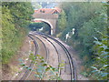
Railway Line West of Bookham
This is the Effingham - Leatherhead line, looking eastwards towards the Little Bookham Street bridge.
Image: © Colin Smith
Taken: 14 Oct 2007
0.22 miles
5
Maddox Lane
Leafy commuter belt Surrey. Large houses in Little Bookham are well hidden behind hedges and trees.
Image: © Colin Smith
Taken: 14 Oct 2007
0.23 miles
6
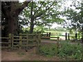
Kissing Gate by Allotments, Bookham Common
Bookham Common is owned by the National Trust www.nationaltrust.org.uk/main/w-global/w-localtoyou/w-south_east/w-south_east-countryside/w-south_east-places-north_downs/w-south_east-places-north_downs-bookham_commons.htm
Image: © Chris Reynolds
Taken: 26 Jul 2009
0.23 miles