IMAGES TAKEN NEAR TO
Ashwood Park, LEATHERHEAD, KT22 9NT
Introduction
This page details the photographs taken nearby to Ashwood Park, KT22 9NT by members of the Geograph project.
The Geograph project started in 2005 with the aim of publishing, organising and preserving representative images for every square kilometre of Great Britain, Ireland and the Isle of Man.

There are currently over 7.5m images from over14,400 individuals and you can help contribute to the project by visiting https://www.geograph.org.uk
Image Map
Images are licensed for reuse under creativecommons.org/licenses/by-sa/2.0
Notes
- Clicking on the map will re-center to the selected point.
- The higher the marker number, the further away the image location is from the centre of the postcode.
Image Listing (9 Images Found)
Images are licensed for reuse under creativecommons.org/licenses/by-sa/2.0
Image
Details
Distance
1
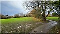
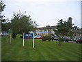
Recreation ground
Park surrounded by dense housing in the middle of Fetcham.
Image: © James Emmans
Taken: 6 Dec 2021
0.07 miles
5
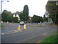
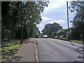
Junction of Lower Road and Bell Lane, Fetcham
Image: © Pip Rolls
Taken: 12 Oct 2005
0.19 miles
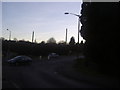
7
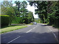
Lower Road at the junction of The Ridgeway
Image: © David Howard
Taken: 6 Dec 2015
0.20 miles
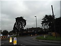
8
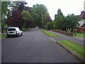
Roundabout on Bell Lane and Lower Road, Fetcham
Image: © David Howard
Taken: 16 Jan 2012
0.21 miles
9
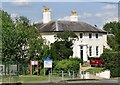
Fetcham Cottage
Historic Fetcham House on Bell Lane in the residential village of Fetcham, west of Leatherhead.
Image: © Colin Smith
Taken: 18 Sep 2021
0.25 miles