IMAGES TAKEN NEAR TO
Shamrock Close, LEATHERHEAD, KT22 9JG
Introduction
This page details the photographs taken nearby to Shamrock Close, KT22 9JG by members of the Geograph project.
The Geograph project started in 2005 with the aim of publishing, organising and preserving representative images for every square kilometre of Great Britain, Ireland and the Isle of Man.

There are currently over 7.5m images from over14,400 individuals and you can help contribute to the project by visiting https://www.geograph.org.uk
Image Map
Images are licensed for reuse under creativecommons.org/licenses/by-sa/2.0
Notes
- Clicking on the map will re-center to the selected point.
- The higher the marker number, the further away the image location is from the centre of the postcode.
Image Listing (38 Images Found)
Images are licensed for reuse under creativecommons.org/licenses/by-sa/2.0
Image
Details
Distance
1
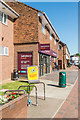
Sainsbury's Local
Mini supermarket in a small parade of shops in Cobham Road.
Image: © Ian Capper
Taken: 26 May 2017
0.05 miles
2
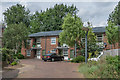
Overlord Court
Development off Pound Crescent by Mole Valley District Council completed in 2005, replacing Moon Court, a group of bedsits dating from the 1950s. The land was originally part of Pound Farm. The name Overlord Court was chosen by residents in memory of the Second World War D-Day military operation in June 1944, in recognition of the involvement of residents of Fetcham and Leatherhead.
Image: © Ian Capper
Taken: 10 Jul 2019
0.06 miles
3
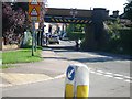
Railway bridge over Cobham Road
Looking south with the River Lane junction in the foreground.
Image: © Andrew Longton
Taken: 8 Sep 2005
0.06 miles
4
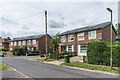
Crescent Cottages
5 houses, 2 of them semi-detached and 3 terraced, on Pound Crescent split by the entrance to Overlord Court. The whole development was carried out by Mole Valley District Council and was completed in 2005, replacing Moon Court, a group of bedsits dating from the 1950s. The land was originally part of Pound Farm.
Image: © Ian Capper
Taken: 10 Jul 2019
0.07 miles
6
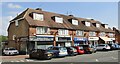
Fetcham - Shopping Parade
Cobham Road - village shops (roofing contractor, barber shop, betting shop) with homes above.
Image: © Colin Smith
Taken: 18 Sep 2021
0.07 miles
7
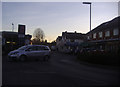
Junction of Cobham Road and The Street, Fetcham
Image: © David Howard
Taken: 16 Jan 2012
0.08 miles
8
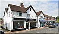
Fetcham - St Clements
The Street - built 1860s when a forge, two cottages and a shop. Rebuilt ca 1932 now occupied (2021) by a barber and post office.
Image: © Colin Smith
Taken: 18 Sep 2021
0.08 miles
9
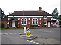
Fetcham Reading Room
Built around 1885 for the benefit of agricultural and domestic workers in the area, it can be found at 181 Cobham Road, opposite the road junction with River Lane. It appears to be still actively used by painting and U3A groups. The Keep Left Bollard is the same one shown in Andrew's photo Image
Image: © Nigel Cox
Taken: 18 Aug 2006
0.10 miles
10
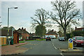
Orchard Close bus stop
On Cobham Road. Orchard Close is out of sight across the road from the bus stop.
Image: © Robin Webster
Taken: 21 Nov 2011
0.10 miles