IMAGES TAKEN NEAR TO
The Berkeleys, LEATHERHEAD, KT22 9DW
Introduction
This page details the photographs taken nearby to The Berkeleys, KT22 9DW by members of the Geograph project.
The Geograph project started in 2005 with the aim of publishing, organising and preserving representative images for every square kilometre of Great Britain, Ireland and the Isle of Man.

There are currently over 7.5m images from over14,400 individuals and you can help contribute to the project by visiting https://www.geograph.org.uk
Image Map
Images are licensed for reuse under creativecommons.org/licenses/by-sa/2.0
Notes
- Clicking on the map will re-center to the selected point.
- The higher the marker number, the further away the image location is from the centre of the postcode.
Image Listing (17 Images Found)
Images are licensed for reuse under creativecommons.org/licenses/by-sa/2.0
Image
Details
Distance
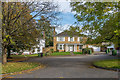
1
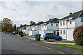
Badingham Drive
Housing forming part of a development that started in 1968 on the former playing fields of Badingham College. This school had been based in Fetcham Park for much of the period from 1927 until 1965 when it moved to Norfolk.
Image: © Ian Capper
Taken: 30 Oct 2019
0.14 miles
2
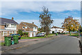
Drayton Close
Cul de sac on the Badingham Drive estate, a development that started in 1968 on the former playing fields of Badingham College. This school had been based in Fetcham Park for much of the period from 1927 until 1965 when it moved to Norfolk.
Image: © Ian Capper
Taken: 30 Oct 2019
0.14 miles
3
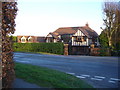
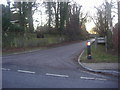
Suburban Leatherhead
Mock Tudor architecture in the last house on Guildford Road, heading uphill from Hawk's Hill towards Bookham. These large and expensive houses have great views southwards over the Mole Gap.
Image: © Colin Smith
Taken: 10 Feb 2008
0.15 miles
4

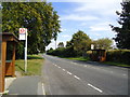
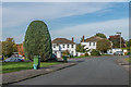
Hawk's Hill, Leatherhead
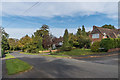
Looking south-west along Guildford Road near the junction with The Mount.
Image: © Andrew Longton
Taken: 20 Sep 2005
0.16 miles
5
Badingham Drive
Housing forming part of a development that started in 1968 on the former playing fields of Badingham College. This school had been based in Fetcham Park for much of the period from 1927 until 1965 when it moved to Norfolk.
Image: © Ian Capper
Taken: 30 Oct 2019
0.17 miles
6
Badingham Drive
Housing forming part of a development that started in 1968 on the former playing fields of Badingham College. This school had been based in Fetcham Park for much of the period from 1927 until 1965 when it moved to Norfolk.
Image: © Ian Capper
Taken: 30 Oct 2019
0.18 miles
7
Badingham Drive
Housing forming part of a development that started in 1968 on the former playing fields of Badingham College. This school had been based in Fetcham Park for much of the period from 1927 until 1965 when it moved to Norfolk.
Image: © Ian Capper
Taken: 30 Oct 2019
0.18 miles
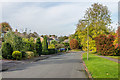
8
The Mount
Upmarket development of land previously forming part of the Fetcham Park estate, sold off by the owners, the Hankey family, in 1924 following the death of Captain Thomas Hankey.
Image: © Ian Capper
Taken: 30 Oct 2019
0.19 miles