IMAGES TAKEN NEAR TO
Wallis Mews, Guildford Road, LEATHERHEAD, KT22 9DQ
Introduction
This page details the photographs taken nearby to Wallis Mews, Guildford Road, KT22 9DQ by members of the Geograph project.
The Geograph project started in 2005 with the aim of publishing, organising and preserving representative images for every square kilometre of Great Britain, Ireland and the Isle of Man.

There are currently over 7.5m images from over14,400 individuals and you can help contribute to the project by visiting https://www.geograph.org.uk
Image Map
Images are licensed for reuse under creativecommons.org/licenses/by-sa/2.0
Notes
- Clicking on the map will re-center to the selected point.
- The higher the marker number, the further away the image location is from the centre of the postcode.
Image Listing (369 Images Found)
Images are licensed for reuse under creativecommons.org/licenses/by-sa/2.0
Image
Details
Distance
1
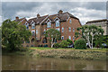
Wallis Mews
1995 development on the site of a former Leatherhead and District Waterworks Company pumping station, seen from across the River Mole. Behind is the later 1935 pumping station.
Image: © Ian Capper
Taken: 11 Jun 2019
0.00 miles
2

Wallis Mews
1995 development on the site of a former Leatherhead and District Waterworks Company pumping station, overlooking the River Mole. Viewed from Leatherhead Bridge, one of whose lampstands is on the left, with the bridges carrying Waterway Road and the Leatherhead - Dorking railway over the river bridge in the background.
Image: © Ian Capper
Taken: 7 Aug 2019
0.00 miles
3
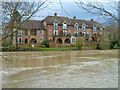
Wallis Mews, Leatherhead across River Mole
The river was overfull and most of the waterside paths were flooded.
Image: © Robin Webster
Taken: 15 Feb 2014
0.01 miles
4
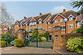
Wallis Mews
1995 development on the site of a former Leatherhead and District Waterworks Company pumping station.
Image: © Ian Capper
Taken: 17 Apr 2019
0.01 miles
5
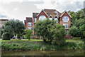
Wallis Mews
1995 development on the site of a former Leatherhead and District Waterworks Company pumping station, seen from across the River Mole. On the left is part of the later 1935 pumping station.
Image: © Ian Capper
Taken: 7 Aug 2019
0.01 miles
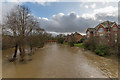
6
River Mole in flood, Leatherhead
Looking downstream from Leatherhead Bridge.
Image: © Robin Webster
Taken: 15 Feb 2014
0.02 miles
7
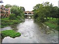
River Mole in Leatherhead
Viewed looking downstream from Leatherhead Bridge towards the B2122 Waterway Road bridge, then the brick railway bridge.
Image: © Nigel Cox
Taken: 20 Sep 2006
0.02 miles
8
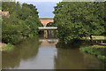
River Mole from Leatherhead bridge
The first bridge is Waterway Road, the B2122, the one behind is the railway from Leatherhead to Dorking.
Image: © Robert Eva
Taken: 13 Jul 2017
0.02 miles
9
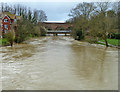
River Mole in flood
A low sun lighting up the River Mole, swollen after a period of heavy rain brought by Storm Dennis, falling on ground already saturated from Storm Ciara a week earlier. Seen from the Waterway Road bridge, with Leatherhead Bridge in the background.
Image: © Ian Capper
Taken: 17 Feb 2020
0.02 miles
10
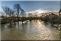
River Mole in flood
The River Mole in flood after a period of heavy rain over the previous few days, looking towards Leatherhead Bridge.
Image: © Ian Capper
Taken: 21 Dec 2019
0.03 miles