IMAGES TAKEN NEAR TO
Guildford Road, LEATHERHEAD, KT22 9AE
Introduction
This page details the photographs taken nearby to Guildford Road, KT22 9AE by members of the Geograph project.
The Geograph project started in 2005 with the aim of publishing, organising and preserving representative images for every square kilometre of Great Britain, Ireland and the Isle of Man.

There are currently over 7.5m images from over14,400 individuals and you can help contribute to the project by visiting https://www.geograph.org.uk
Image Map
Images are licensed for reuse under creativecommons.org/licenses/by-sa/2.0
Notes
- Clicking on the map will re-center to the selected point.
- The higher the marker number, the further away the image location is from the centre of the postcode.
Image Listing (251 Images Found)
Images are licensed for reuse under creativecommons.org/licenses/by-sa/2.0
Image
Details
Distance
1
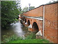
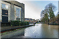
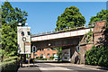
Leatherhead Bridge
This 14 arch bridge, which dates from medieval times, carries Guildford Road over the River Mole.
Image: © Nigel Cox
Taken: 20 Sep 2006
0.00 miles
2
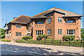
Cedar Court
Office block on Guildford Road, housing among others the NHS Surrey Downs Clinical Commissioning Group. Until 1998, this was the site of a large house called Fetcham Grove, originally dating from at least the 18th Century. Originally a private house, for many years this had been occupied by the intriguingly named Green Domino Hotel & Restaurant until closure in the 1940s, after which it was used by a removals firm as a depository.
Image: © Ian Capper
Taken: 26 May 2017
0.01 miles
3
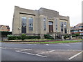
Leatherhead Pumping Station
"New Works" built in 1935
Image: © The Saunterer
Taken: 30 Nov 2013
0.04 miles
4
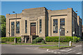
Leatherhead Pumping Station
Water pumping station built in 1935 and extended in 1940.
Image: © Ian Capper
Taken: 26 May 2017
0.04 miles
5
Grove House
Office block built in the grounds of what was until 1998, the site of a large house called Fetcham Grove, originally dating from at least the 18th Century. Originally a private house, for many years this had been occupied by the intriguingly named Green Domino Hotel & Restaurant until closure in the 1940s, after which it was used by a removals firm as a depository.
Image: © Ian Capper
Taken: 11 Jul 2019
0.04 miles
6
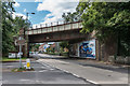
Railway bridge
Bridge carrying the Leatherhead to Dorking railway over Guildford Road.
Image: © Ian Capper
Taken: 15 Aug 2019
0.04 miles
7
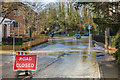
Waterway Road - in flood
Waterway Road under water where it meets Guildford Road. The flooding is as a result of high water levels in the nearby River Mole after a period of heavy rain brought by Storm Dennis, falling on ground already saturated from Storm Ciara a week earlier. The building on the left is Leatherhead Pumping Station - see Image
Image: © Ian Capper
Taken: 17 Feb 2020
0.04 miles
8
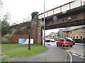
Railway bridge on Guildford Road, Leatherhead
At the entrance to the leisure centre
Image: © David Howard
Taken: 7 Apr 2014
0.05 miles
9
Railway Bridge, Guildford Road
Bridge carrying the Leatherhead to Dorking railway over Guildford Road.
Image: © Ian Capper
Taken: 26 May 2017
0.05 miles
10
Guildford Road - flooding
Flooding on Guildford Road near its junction with Waterway Road, seen in the background. This had arisen from high water levels on the River Mole after a period of heavy rain brought by Storm Dennis, falling on ground already saturated from Storm Ciara a week earlier. Some vehicles were able to make it through the flood, but not the Mercedes stranded near the junction.
Image: © Ian Capper
Taken: 17 Feb 2020
0.06 miles