IMAGES TAKEN NEAR TO
Quarry Close, LEATHERHEAD, KT22 8US
Introduction
This page details the photographs taken nearby to Quarry Close, KT22 8US by members of the Geograph project.
The Geograph project started in 2005 with the aim of publishing, organising and preserving representative images for every square kilometre of Great Britain, Ireland and the Isle of Man.

There are currently over 7.5m images from over14,400 individuals and you can help contribute to the project by visiting https://www.geograph.org.uk
Image Map
Images are licensed for reuse under creativecommons.org/licenses/by-sa/2.0
Notes
- Clicking on the map will re-center to the selected point.
- The higher the marker number, the further away the image location is from the centre of the postcode.
Image Listing (41 Images Found)
Images are licensed for reuse under creativecommons.org/licenses/by-sa/2.0
Image
Details
Distance
1
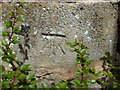
Cut Mark on garden wall
Along Green Lane Leatherhead
Image: © dave-harris
Taken: 18 Apr 2012
0.05 miles
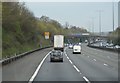
4
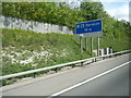
M25 anti-clockwise, sign to next services
Image: © Colin Pyle
Taken: 13 May 2013
0.08 miles
5
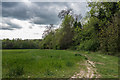
Field edge
Field edge alongside Ermyn Way. The M25 runs behind the trees in the left background.
Image: © Ian Capper
Taken: 28 Apr 2017
0.08 miles
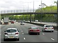
6
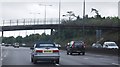
Footbridge over the M25, near Leatherhead
Image: © N Chadwick
Taken: 23 Aug 2010
0.08 miles
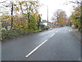
7
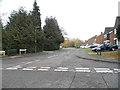
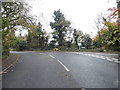
Hatherwood at the junction of Ermyn Way
Image: © David Howard
Taken: 16 Nov 2014
0.09 miles
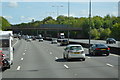
8
Footbridge over the M25 near Leatherhead
Image: © David Dixon
Taken: 13 May 2013
0.09 miles