IMAGES TAKEN NEAR TO
Sherborne Walk, LEATHERHEAD, KT22 8UL
Introduction
This page details the photographs taken nearby to Sherborne Walk, KT22 8UL by members of the Geograph project.
The Geograph project started in 2005 with the aim of publishing, organising and preserving representative images for every square kilometre of Great Britain, Ireland and the Isle of Man.

There are currently over 7.5m images from over14,400 individuals and you can help contribute to the project by visiting https://www.geograph.org.uk
Image Map
Images are licensed for reuse under creativecommons.org/licenses/by-sa/2.0
Notes
- Clicking on the map will re-center to the selected point.
- The higher the marker number, the further away the image location is from the centre of the postcode.
Image Listing (173 Images Found)
Images are licensed for reuse under creativecommons.org/licenses/by-sa/2.0
Image
Details
Distance
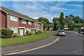
1
Sherborne Walk, Windfield
c1960s/70s housing on land between Epsom Road and Poplar Road on what was the grounds of a large house named Windfield.
Image: © Ian Capper
Taken: 15 May 2019
0.01 miles
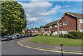
2
Poplar Road
1960s terrace of bungalows in Poplar Road.
Image: © Ian Capper
Taken: 15 May 2019
0.04 miles
3
Windfield
c1960s/70s housing on land between Epsom Road and Poplar Road on what was the grounds of a large house named Windfield.
Image: © Ian Capper
Taken: 31 Jul 2019
0.05 miles
4

St John's Road
Victorian housing on St John's Road. In the background is part of St John's School.
Image: © Ian Capper
Taken: 15 May 2019
0.05 miles
5
Leach Grove
Mid 20th Century cul-de-sac off Poplar Road.
Image: © Ian Capper
Taken: 31 Jul 2019
0.06 miles
6
Windfield
c1960s/70s housing on land between Epsom Road and Poplar Road on what was the grounds of a large house named Windfield.
Image: © Ian Capper
Taken: 31 Jul 2019
0.06 miles
7
Windfield
c1960s/70s housing on land between Epsom Road and Poplar Road on what was the grounds of a large house named Windfield.
Image: © Ian Capper
Taken: 31 Jul 2019
0.06 miles
8

St John's Road
Victorian housing on St John's Road, seen from its junction with Poplar Road. In the background is part of St John's School.
Image: © Ian Capper
Taken: 15 May 2019
0.06 miles
9
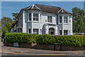
1 St John's Road
Victorian Villa, now housing a dental practice.
Image: © Ian Capper
Taken: 15 May 2019
0.07 miles
10
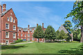
Main building, St John's School
The main building at St John's School, Leatherhead, built in 1872 and rebuilt in 1913 after a fire. On the right is the old chapel, dedicated in 1877 and in use as such until replaced by the new chapel in 1963 (see Image). It is now used for exhibitions and concerts.
Image: © Ian Capper
Taken: 4 Jul 2019
0.08 miles