IMAGES TAKEN NEAR TO
Reigate Road, LEATHERHEAD, KT22 8QX
Introduction
This page details the photographs taken nearby to Reigate Road, KT22 8QX by members of the Geograph project.
The Geograph project started in 2005 with the aim of publishing, organising and preserving representative images for every square kilometre of Great Britain, Ireland and the Isle of Man.

There are currently over 7.5m images from over14,400 individuals and you can help contribute to the project by visiting https://www.geograph.org.uk
Image Map
Images are licensed for reuse under creativecommons.org/licenses/by-sa/2.0
Notes
- Clicking on the map will re-center to the selected point.
- The higher the marker number, the further away the image location is from the centre of the postcode.
Image Listing (40 Images Found)
Images are licensed for reuse under creativecommons.org/licenses/by-sa/2.0
Image
Details
Distance
1
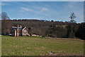
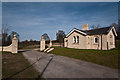
Gardener's Cottage, Cherkley Court
Cottage on the Cherkley Court Estate. In the background is Cherkley Wood with the 40 Acre Field (see Image) in front of it.
Image: © Ian Capper
Taken: 25 Mar 2012
0.02 miles
2
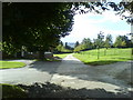
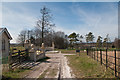
Drive to Cherkley Court
Drive to Cherkley Court (http://www.cherkleycourt.com/), which is out of sight down the hill. The building on the left is The Garden House.
Image: © Martyn Davies
Taken: 9 Oct 2006
0.04 miles
3
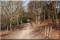
Stane Street
A byway running along the course of the old Roman Road from London to Chichester, here crossing the Cherkley Court estate.
Image: © Ian Capper
Taken: 25 Mar 2012
0.10 miles
4
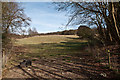
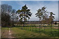
40 Acre Field
View onto 40 Acre Field from Stane Street.
40 Acre Field is an area of chalk grassland on the Cherkley estate, currently used for grazing. Prior to 2010, Cherkley was owned by the Beaverbrook Foundation. In that year, it was sold to Longshot, a property development company, looking to convert Cherkley Court into a luxury hotel and much of the estate into an exclusive golf course. Under their plans, this field would be sprayed with a total herbicide, stripped of its topsoil, reprofiled, and then used for part of the proposed golf course, thus ruining a valuable and rare habitat. At the time of submission, a decision by Mole Valley District Council on the planning application is awaited, although the advice from Council officers is that the golf course application should be refused.
Update: on 4 April 2012, the MVDC planning committee narrowly voted to reject the officers' detailed report, effectively ignoring the Council's own planning policy for the sake of the "prestige" that the proposed development will bring the area. It was also argued by those voting to reject the advice that the golf course would somehow enhance the landscape and increase biodiversity, would have no adverse impact on water resources and, most interestingly of all, would ensure that public access to Cherkley Court would be maintained (despite the exclusivity tag being applied to the development). Admittedly the vote was not yet to approve planning permission which will now be referred to a follow up meeting, which will also decide on conditions that would be attached to such approval, if granted, but it seems like the start of a slippery slope.
Image: © Ian Capper
Taken: 25 Mar 2012
0.12 miles
5
Upper Lodge, Cherkley Court
Grade II listed lodge, dating from around 1870. For listing particulars see www.historicengland.org.uk/listing/the-list/list-entry/1191011. The gate piers and wall are separately grade II listed - see www.historicengland.org.uk/listing/the-list/list-entry/1378210.
Image: © Ian Capper
Taken: 25 Mar 2012
0.12 miles
6
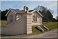
Upper Lodge, Cherkley Court
Grade II listed lodge, dating from around 1870. For listing particulars see www.historicengland.org.uk/listing/the-list/list-entry/1191011. The gate piers and wall are separately grade II listed - see www.historicengland.org.uk/listing/the-list/list-entry/1378210.
Image: © Ian Capper
Taken: 25 Mar 2012
0.13 miles
7
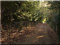
Stane Street
The Roman road, followed by byway 118 and the Thames Down Link, runs through a grove of yews close to Cherkley Court.
Image: © Derek Harper
Taken: 3 Feb 2011
0.13 miles
8
Mill Way
A bridleway across the Leatherhead Downs, seen here as it crosses the Cherkley Court Estate.
Image: © Ian Capper
Taken: 25 Mar 2012
0.13 miles
9
Mill Way
A bridleway across the Leatherhead Downs, seen here as it crosses the Cherkley Court Estate, with the Upper Lodge on the left.
Image: © Ian Capper
Taken: 25 Mar 2012
0.13 miles
10
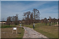
Cherkley Court driveway
Access drive to Cherkley Court, viewed from the Mill Way bridleway. The area beyond the fence, known as the Northern Parkland, is under threat from conversion by the present owners of the Cherkley estate, Longshot, into an exclusive golf course.
Image: © Ian Capper
Taken: 25 Mar 2012
0.14 miles