IMAGES TAKEN NEAR TO
Glenheadon Rise, LEATHERHEAD, KT22 8QT
Introduction
This page details the photographs taken nearby to Glenheadon Rise, KT22 8QT by members of the Geograph project.
The Geograph project started in 2005 with the aim of publishing, organising and preserving representative images for every square kilometre of Great Britain, Ireland and the Isle of Man.

There are currently over 7.5m images from over14,400 individuals and you can help contribute to the project by visiting https://www.geograph.org.uk
Image Map
Images are licensed for reuse under creativecommons.org/licenses/by-sa/2.0
Notes
- Clicking on the map will re-center to the selected point.
- The higher the marker number, the further away the image location is from the centre of the postcode.
Image Listing (13 Images Found)
Images are licensed for reuse under creativecommons.org/licenses/by-sa/2.0
Image
Details
Distance
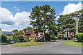
4
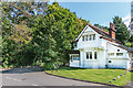
Court Lodge
Former lodge to Yarm Court, situated at the junction of Fir Tree Road (on the line of the original drive to the main house) and Reigate Road. The lodge is the only survivor of the estate, the area having been developed in 1935.
Image: © Ian Capper
Taken: 13 Aug 2019
0.16 miles
6

Yarm Way
Housing on the land of the former Yarm Court, developed in 1935.
Image: © Ian Capper
Taken: 13 Aug 2019
0.17 miles
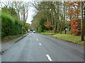
9
Fir Tree Road
Housing on the land of the former Yarm Court, developed in 1935.
Image: © Ian Capper
Taken: 13 Aug 2019
0.20 miles