IMAGES TAKEN NEAR TO
Tyrrells Wood, LEATHERHEAD, KT22 8QP
Introduction
This page details the photographs taken nearby to Tyrrells Wood, KT22 8QP by members of the Geograph project.
The Geograph project started in 2005 with the aim of publishing, organising and preserving representative images for every square kilometre of Great Britain, Ireland and the Isle of Man.

There are currently over 7.5m images from over14,400 individuals and you can help contribute to the project by visiting https://www.geograph.org.uk
Image Map
Images are licensed for reuse under creativecommons.org/licenses/by-sa/2.0
Notes
- Clicking on the map will re-center to the selected point.
- The higher the marker number, the further away the image location is from the centre of the postcode.
Image Listing (17 Images Found)
Images are licensed for reuse under creativecommons.org/licenses/by-sa/2.0
Image
Details
Distance
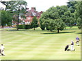
1
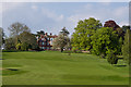
Tyrrell's Wood Golf Course
Part of Tyrrell's Wood Golf Course. In the background is the clubhouse, originally a private house built in 1889 for banker Roger Cunliffe of nearby Headley Court. It is grade II listed - see http://www.historicengland.org.uk/listing/the-list/list-entry/1028595.
Image: © Ian Capper
Taken: 6 May 2013
0.01 miles
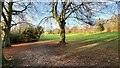
2
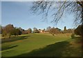
Tyrrells Wood
The building, now the clubhouse for Tyrrells Wood Golf Club, was built in the "Queen Anne style" in the 1880s http://www.britishlistedbuildings.co.uk/en-290568-tyrrells-wood-leatherhead . This view is from bridleway BW512 near Mill Way.
Image: © Derek Harper
Taken: 3 Feb 2011
0.02 miles
3
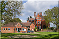
Tyrrell's Wood Golf Club
The main house dates from 1889 and was built for banker Roger Cunliffe of nearby Headley Court. It is grade II listed - see http://www.historicengland.org.uk/listing/the-list/list-entry/1028595.
The golf club was founded in 1924.
Image: © Ian Capper
Taken: 6 May 2013
0.02 miles
4
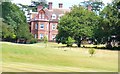
Tyrrells Wood
Impressive large brick building, the clubhouse for Tyrells Wood Golf Club.
http://www.tyrrellswoodgolfclub.com/default.asp
Image: © Colin Smith
Taken: 10 Jul 2009
0.03 miles
5
Tyrells Wood Golf Course
Upmarket golf club on the Leatherhead Downs - a parkland setting on the North Downs.
http://www.tyrrellswoodgolfclub.com/default.asp
Image: © Colin Smith
Taken: 10 Jul 2009
0.07 miles
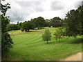
6
Tyrrell's Wood Golf Club
The club house is in the distance.
Image: © James Emmans
Taken: 8 Dec 2021
0.13 miles
7
Stane Street
The route of Stane Street, the Roman road from Londinium (London) to Noviomagus Reginorum (Chichester).
Image: © Ian Capper
Taken: 6 May 2013
0.14 miles
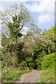
9
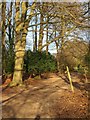
Bridleway, Tyrrells Wood Golf Course
The sign pointing the way for bridleway BW512 looks a little apologetic.
Image: © Derek Harper
Taken: 3 Feb 2011
0.16 miles
10
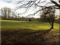
Tyrrells Wood Golf Course
A view across the links, as shadows lengthen, from bridleway BW512.
Image: © Derek Harper
Taken: 3 Feb 2011
0.17 miles