IMAGES TAKEN NEAR TO
Tate Close, LEATHERHEAD, KT22 8PQ
Introduction
This page details the photographs taken nearby to Tate Close, KT22 8PQ by members of the Geograph project.
The Geograph project started in 2005 with the aim of publishing, organising and preserving representative images for every square kilometre of Great Britain, Ireland and the Isle of Man.

There are currently over 7.5m images from over14,400 individuals and you can help contribute to the project by visiting https://www.geograph.org.uk
Image Map
Images are licensed for reuse under creativecommons.org/licenses/by-sa/2.0
Notes
- Clicking on the map will re-center to the selected point.
- The higher the marker number, the further away the image location is from the centre of the postcode.
Image Listing (37 Images Found)
Images are licensed for reuse under creativecommons.org/licenses/by-sa/2.0
Image
Details
Distance
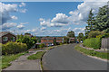
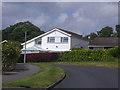
2
Winter Scene
A small green space on Windmill Drive
Image: © Martyn Davies
Taken: 4 Jan 2009
0.07 miles
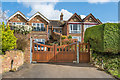
4
Ashby, Buckland, Capel, Charlwood and Dunsfold
Two semi-detached and one detached houses in the Windmills built in 2016 on the site of Highlands House, a large house which had been built in 1897 for Henry Moore, a prominent local corn chandler and miller.
Image: © Ian Capper
Taken: 30 Apr 2019
0.10 miles
5
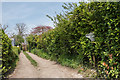
Worple Road
The southern end of Worple Road, a track between The Driftway with Church Road, which long predated any development in the area. Note the (broken) "Bridleway No Motor Vehicles" sign; there is a similar (complete) one at the other end - see Image Although the sign suggests that this is a bridleway, the Surrey County Council Rights of Way map marks it as a footpath, FP57.
Image: © Ian Capper
Taken: 18 Apr 2019
0.11 miles
6
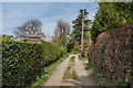
Worple Road
The southern end of Worple road, a track between The Driftway with Church Road, which long predated any development in the area.
Image: © Ian Capper
Taken: 18 Apr 2019
0.11 miles
7
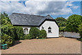
Leedom Lodge
Late 19th Century lodge where Worple Road meets The Driftway, although to what property it was the lodge is not clear.
Image: © Ian Capper
Taken: 13 Aug 2019
0.11 miles
8
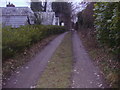
Bridleway Leatherhead
Linking Downs Lane and Worple Road
Image: © David Howard
Taken: 7 Feb 2010
0.11 miles
9
Modern house on Windmill Drive, Leatherhead
Image: © David Howard
Taken: 18 May 2009
0.12 miles
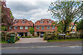
10
Elm Bank Cottages
Pair of cottages, now on St Mary's Road but originally accessed from Worple Road to the rear. The plaques in the gables give building dates of 1869 (in the case of Elmbank Cottage on the left) and 1871 (in the case of Elm Cottage on the right), long predating the development of the rest of St Mary's Road in the 1920s/30s after the 21½ acre grounds of Elm Bank House were sold off. Both also have the initials ETR on a separate plaque, presumably the builder.
Image: © Ian Capper
Taken: 12 Mar 2020
0.12 miles