IMAGES TAKEN NEAR TO
Highlands Road, LEATHERHEAD, KT22 8NW
Introduction
This page details the photographs taken nearby to Highlands Road, KT22 8NW by members of the Geograph project.
The Geograph project started in 2005 with the aim of publishing, organising and preserving representative images for every square kilometre of Great Britain, Ireland and the Isle of Man.

There are currently over 7.5m images from over14,400 individuals and you can help contribute to the project by visiting https://www.geograph.org.uk
Image Map
Images are licensed for reuse under creativecommons.org/licenses/by-sa/2.0
Notes
- Clicking on the map will re-center to the selected point.
- The higher the marker number, the further away the image location is from the centre of the postcode.
Image Listing (55 Images Found)
Images are licensed for reuse under creativecommons.org/licenses/by-sa/2.0
Image
Details
Distance
1
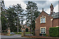
56 Highlands Road
Former lodge of the Royal School for the Blind (originally the School for the Indigent Blind and later SeeAbility), dating from 1902 after the school moved here from Southwark. With the move by the charity to more community based support, much of the site was sold in the late 1990s, with the main block (part of which is visible in the background to this photo) being converted for housing (Lavender Court and Close) and the western part of the site being developed with new housing (Beechwood Park). The lodge was converted to a private residence at the same time. SeeAbility is now located in Wesley Road, on the southern part of the site.
Image: © Ian Capper
Taken: 30 Apr 2019
0.03 miles
2
56 Highlands Road
Former lodge of the Royal School for the Blind (originally the School for the Indigent Blind and later SeeAbility), dating from 1902 after the school moved here from Southwark. With the move by the charity to more community based support, much of the site was sold in the late 1990s, with the main block being converted for housing (Lavender Court and Close) and the western part of the site being developed with new housing (Beechwood Park). The lodge was converted to a private residence at the same time. SeeAbility is now located in Wesley Road, on the southern part of the site.
Image: © Ian Capper
Taken: 30 Apr 2019
0.03 miles
3

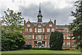
Lavender Court
Former main building of the Royal School for the Blind (originally the School for the Indigent Blind and later SeeAbility), dating from 1902 after the school moved here from Southwark. During the Second World War it was used by King's College Hospital for part of the Emergency Medical Service. After decommissioning in 1946 it became an infirmary for Chelsea Pensioners in which role it served until 1956. It was then modernised and was restored to its original use in 1958. With the move by the charity to more community based support, much of the site was sold in the late 1990s, with the main block being converted for housing (Lavender Court and Close) and the western part of the site being developed with new housing (Beechwood Park). SeeAbility is now located in Wesley Road, on the southern part of the site.
Image: © Ian Capper
Taken: 30 Apr 2019
0.06 miles
4
Lavender Court
Former main building of the Royal School for the Blind (originally the School for the Indigent Blind and later SeeAbility), dating from 1902 after the school moved here from Southwark. During the Second World War it was used by King's College Hospital for part of the Emergency Medical Service. After decommissioning in 1946 it became an infirmary for Chelsea Pensioners in which role it served until 1956. It was then modernised and was restored to its original use in 1958. With the move by the charity to more community based support, much of the site was sold in the late 1990s, with the main block being converted for housing (Lavender Court and Close) and the western part of the site being developed with new housing (Beechwood Park). SeeAbility is now located in Wesley Road, on the southern part of the site.
Image: © Ian Capper
Taken: 30 Apr 2019
0.06 miles
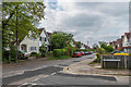
5
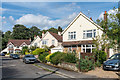
Highlands Avenue
c1930s houses in a cul-de-sac off Highlands Road.
Image: © Ian Capper
Taken: 31 Jul 2019
0.08 miles
6
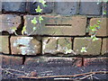
CBM on Highlands Rd at the Junction with Reigate Road
Image: © dave-harris
Taken: 29 Apr 2012
0.08 miles
7
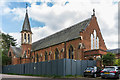
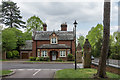
Former chapel
Former chapel of the Royal School for the Blind (originally the School for the Indigent Blind and later SeeAbility), dating from 1902 after the school moved here from Southwark. With the move by the charity to more community based support, much of the site was sold in the late 1990s, with the main block being converted for housing (Lavender Court and Close) and the western part of the site being developed with new housing (Beechwood Park). SeeAbility is now located in Wesley Road, on the southern part of the site.
The chapel was converted to serviced offices for local entrepreneurs, known as the Chapel of Ideas. (At the time of this photo, the building had recently been sold, and the boarding would suggest that it might be undergoing work).
Image: © Ian Capper
Taken: 30 Apr 2019
0.09 miles
8
Highlands Road
c1930s houses in Highlands Road.
Image: © Ian Capper
Taken: 31 Jul 2019
0.09 miles
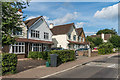
9
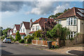
Highlands Road
Early 20th Century housing in Highlands Road.
Image: © Ian Capper
Taken: 30 Apr 2019
0.10 miles
10
Highlands Avenue
c1930s houses in a cul-de-sac off Highlands Road.
Image: © Ian Capper
Taken: 31 Jul 2019
0.11 miles