IMAGES TAKEN NEAR TO
Highlands Close, LEATHERHEAD, KT22 8NG
Introduction
This page details the photographs taken nearby to Highlands Close, KT22 8NG by members of the Geograph project.
The Geograph project started in 2005 with the aim of publishing, organising and preserving representative images for every square kilometre of Great Britain, Ireland and the Isle of Man.

There are currently over 7.5m images from over14,400 individuals and you can help contribute to the project by visiting https://www.geograph.org.uk
Image Map
Images are licensed for reuse under creativecommons.org/licenses/by-sa/2.0
Notes
- Clicking on the map will re-center to the selected point.
- The higher the marker number, the further away the image location is from the centre of the postcode.
Image Listing (319 Images Found)
Images are licensed for reuse under creativecommons.org/licenses/by-sa/2.0
Image
Details
Distance
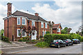
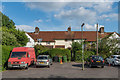
1
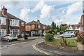
Highlands Close
c1930s cul-de-sac off Highlands Road.
Image: © Ian Capper
Taken: 31 Jul 2019
0.01 miles
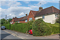
2
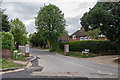
St Nicholas Hill
Private road first developed in 1911.
Image: © Ian Capper
Taken: 30 Apr 2019
0.03 miles
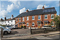
3
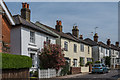
Highlands Road
Late Victorian semi-detached villas in Highlands Road.
Image: © Ian Capper
Taken: 18 Apr 2019
0.04 miles
4
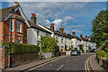
Highlands Road
Late Victorian semi-detached villas in Highlands Road. The exception is the house on the far left of the photo, which was originally the headmaster's house for the adjacent Highlands Road National School.
Image: © Ian Capper
Taken: 31 Jul 2019
0.04 miles
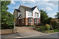
5
30 Highlands Road
Early 20th Century house in Highlands Road.
Image: © Ian Capper
Taken: 30 Apr 2019
0.05 miles
6
6 - 16 Poplar Road
c1930s housing in Poplar Road.
Image: © Ian Capper
Taken: 31 Jul 2019
0.05 miles
7
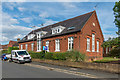
Old School Court
Former school in Poplar Road, built in 1883 as a girls' school, becoming a mixed primary school in 1913. The school moved to Forty Foot Road in 1986, with the original building converted for housing.
Image: © Ian Capper
Taken: 31 Jul 2019
0.05 miles
8
4b Poplar Road
Fill-in house alongside Old School Court in Poplar Road.
Image: © Ian Capper
Taken: 31 Jul 2019
0.06 miles
9
Poplar Avenue
c1930s housing off Poplar Road.
Image: © Ian Capper
Taken: 31 Jul 2019
0.06 miles
10
Highlands Mews
Terrace in Highlands Road built in 2006 on the site of a former school, the Boy's National School built in 1838, and later used as a warehouse. The terrace beyond are 19th Century, marked on the 1869-82 1:2500 map as Inkerman Terrace, but now simply numbered as 35 - 41 Church Road, from which they are accessed by a footpath.
Image: © Ian Capper
Taken: 31 Jul 2019
0.06 miles