IMAGES TAKEN NEAR TO
St. Nicholas Hill, LEATHERHEAD, KT22 8NE
Introduction
This page details the photographs taken nearby to St. Nicholas Hill, KT22 8NE by members of the Geograph project.
The Geograph project started in 2005 with the aim of publishing, organising and preserving representative images for every square kilometre of Great Britain, Ireland and the Isle of Man.

There are currently over 7.5m images from over14,400 individuals and you can help contribute to the project by visiting https://www.geograph.org.uk
Image Map
Images are licensed for reuse under creativecommons.org/licenses/by-sa/2.0
Notes
- Clicking on the map will re-center to the selected point.
- The higher the marker number, the further away the image location is from the centre of the postcode.
Image Listing (222 Images Found)
Images are licensed for reuse under creativecommons.org/licenses/by-sa/2.0
Image
Details
Distance
1
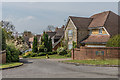
The Limes
Mid 1990s cul-de-sac off St Nicholas Hill.
Image: © Ian Capper
Taken: 18 Apr 2019
0.03 miles
2
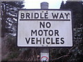
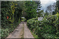
Pre-Worboys bridleway sign, Leatherhead
This cast iron sign was in remarkably good condition (including a new pole) considering they officially stopped being made in 1963. There was another one at the other end of the bridleway in Downs Road but had a corner missing, an intrinsic problem with using brittle cast iron.
Image: © David Howard
Taken: 7 Feb 2010
0.04 miles
3
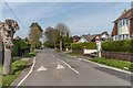
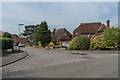
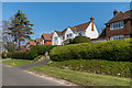
St Nicholas Hill
Private road, first developed in 1911. On the right is White Gates, one of the original houses in the road - see Image
Image: © Ian Capper
Taken: 18 Apr 2019
0.05 miles
4
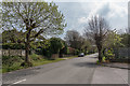
St Nicholas Hill
Private road, first developed in 1911.
Image: © Ian Capper
Taken: 18 Apr 2019
0.05 miles
5
Orchardleigh
c1960s cul-de-sac off St Nicholas Hill.
Image: © Ian Capper
Taken: 18 Apr 2019
0.06 miles
6
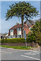
White Gates
One of the original houses in St Nicholas Hill, first developed in 1911.
Image: © Ian Capper
Taken: 18 Apr 2019
0.07 miles
7
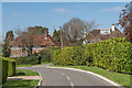
St Mary's Road
Upmarket road developed after 1924, when the 21½ acre grounds of Elm Bank House were sold off.
Image: © Ian Capper
Taken: 11 Apr 2019
0.08 miles
9
St Mary's Road
Upmarket road developed after 1924, when the 21½ acre grounds of Elm Bank House were sold off.
Image: © Ian Capper
Taken: 11 Apr 2019
0.09 miles
10
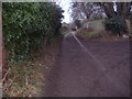
Worple Road
Named track running south from Highlands Road/Church Road, predating much of the development of the area. (Worple means "trackway"). Note the bridleway sign on the right; there is a similar one at the other end - see Image Although the sign suggests that this is a bridleway, the Surrey County Council Rights of Way map marks it as a footpath, FP57.
Image: © Ian Capper
Taken: 30 Apr 2019
0.10 miles