IMAGES TAKEN NEAR TO
The Downs, LEATHERHEAD, KT22 8LX
Introduction
This page details the photographs taken nearby to The Downs, KT22 8LX by members of the Geograph project.
The Geograph project started in 2005 with the aim of publishing, organising and preserving representative images for every square kilometre of Great Britain, Ireland and the Isle of Man.

There are currently over 7.5m images from over14,400 individuals and you can help contribute to the project by visiting https://www.geograph.org.uk
Image Map
Images are licensed for reuse under creativecommons.org/licenses/by-sa/2.0
Notes
- Clicking on the map will re-center to the selected point.
- The higher the marker number, the further away the image location is from the centre of the postcode.
Image Listing (22 Images Found)
Images are licensed for reuse under creativecommons.org/licenses/by-sa/2.0
Image
Details
Distance
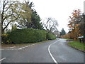
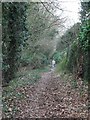
1
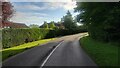
The Downs
Windy road through the housing estate.
Image: © James Emmans
Taken: 14 Aug 2021
0.04 miles
3
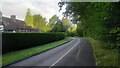
Givons Grove - The Downs
Entrance road from the A24 leatherhead bypass.
Image: © James Emmans
Taken: 14 Aug 2021
0.11 miles
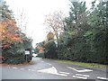
7
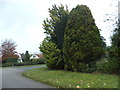
Conifers on Crabtree Drive, Givons Grove
Image: © David Howard
Taken: 16 Nov 2014
0.16 miles