IMAGES TAKEN NEAR TO
Church Road, LEATHERHEAD, KT22 8AD
Introduction
This page details the photographs taken nearby to Church Road, KT22 8AD by members of the Geograph project.
The Geograph project started in 2005 with the aim of publishing, organising and preserving representative images for every square kilometre of Great Britain, Ireland and the Isle of Man.

There are currently over 7.5m images from over14,400 individuals and you can help contribute to the project by visiting https://www.geograph.org.uk
Image Map
Images are licensed for reuse under creativecommons.org/licenses/by-sa/2.0
Notes
- Clicking on the map will re-center to the selected point.
- The higher the marker number, the further away the image location is from the centre of the postcode.
Image Listing (485 Images Found)
Images are licensed for reuse under creativecommons.org/licenses/by-sa/2.0
Image
Details
Distance
1
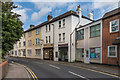
Surrey Court
Row of buildings on The Crescent, now housing various businesses with flats above.
Image: © Ian Capper
Taken: 15 Aug 2019
0.01 miles
3
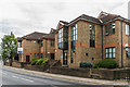
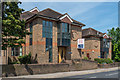
15 - 17 and 19 - 21 The Crescent
A pair of office blocks on The Crescent.
Image: © Ian Capper
Taken: 2 May 2019
0.02 miles
4
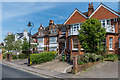
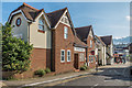
1, 3 - 5 and 7 - 9 Church Road
Buildings at the north end of Church Road. No 1 (forming part of Denver Court) is a sympathetic replacement of a late Victorian villa (see Image for the original before demolition) while nos 3 - 5 and 7 - 9 are early 20th Century.
Image: © Ian Capper
Taken: 15 May 2019
0.02 miles
5
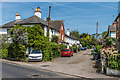
Waverley Place
Short road linking The Crescent with Church Road.
Image: © Ian Capper
Taken: 15 May 2019
0.02 miles
6
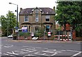
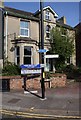
Old villa in process of demolition, Church Road
This old villa, on the corner of Church Road and Epsom Road, was in the early stages of demolition, when photographed in August 2010. There is to be a residential development on the site.
Image: © P L Chadwick
Taken: 14 Aug 2010
0.02 miles
7
52 High Street
Offices at the eastern end of High Street.
Image: © Ian Capper
Taken: 31 Jul 2019
0.02 miles
8
Byron Place
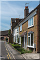
Late Victorian cul de sac off Church Road, named after Admiral Byron, great uncle of the poet Lord Byron, who lived in Linden House, situated where Linden Court now stands.
Image: © Ian Capper
Taken: 15 May 2019
0.02 miles
9
15 - 17 and 19 - 21 The Crescent
A pair of office blocks on The Crescent.
Image: © Ian Capper
Taken: 15 May 2019
0.03 miles
10
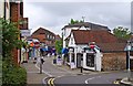
High Street
Most of the High Street is now pedestrianised. This is where the pedestrianised part begins.
Image: © P L Chadwick
Taken: 14 Aug 2010
0.03 miles