IMAGES TAKEN NEAR TO
Kingston Road, LEATHERHEAD, KT22 7SL
Introduction
This page details the photographs taken nearby to Kingston Road, KT22 7SL by members of the Geograph project.
The Geograph project started in 2005 with the aim of publishing, organising and preserving representative images for every square kilometre of Great Britain, Ireland and the Isle of Man.

There are currently over 7.5m images from over14,400 individuals and you can help contribute to the project by visiting https://www.geograph.org.uk
Image Map
Images are licensed for reuse under creativecommons.org/licenses/by-sa/2.0
Notes
- Clicking on the map will re-center to the selected point.
- The higher the marker number, the further away the image location is from the centre of the postcode.
Image Listing (179 Images Found)
Images are licensed for reuse under creativecommons.org/licenses/by-sa/2.0
Image
Details
Distance
1
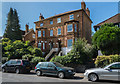
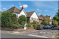
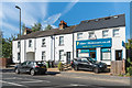
33 - 35 Kingston Road
Pair of Victorian semi-detached houses, first marked on the 1896 1:2,500 map.
Image: © Ian Capper
Taken: 18 Sep 2019
0.01 miles
2
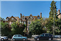
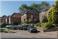
27a and 29 - 31 Kingston Road
Two houses on Kingston Road. Nos 29 - 31, on the left, is a pair of semi-detached Victorian houses marked on the 1869 1:2,500 map. No 27a is much more recent.
Image: © Ian Capper
Taken: 18 Sep 2019
0.01 miles
3
27a and 29 - 31 Kingston Road
Two houses on Kingston Road. Nos 29 - 31, on the left, is a pair of semi-detached Victorian houses marked on the 1869 1:2,500 map. No 27a is much more recent.
Image: © Ian Capper
Taken: 18 Sep 2019
0.01 miles
4
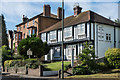
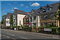
37 - 39 Kingston Road
c1930s semi-detached house on Kingston Road, the right hand side of which since 1993 has been a guest house, Swan Guest House. There have been a number of proposals over the year for demolition and replacement with a block of flats.
Image: © Ian Capper
Taken: 13 Sep 2019
0.02 miles
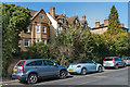
5
Kings Court
Office block built in the late 1990s on the site of Ashetree Works, which had been used by Ashe Laboratories who manufactured pharmaceutical, toiletry, hair care, dietary, veterinary, baby care products.
Image: © Ian Capper
Taken: 13 Sep 2019
0.03 miles
6
Kingston Avenue
Road between Kingston Road and St John's Avenue first laid out in the early 1900s.
Image: © Ian Capper
Taken: 5 Sep 2019
0.03 miles
7
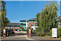
Churchill Retirement Living
Retirement apartment complex on Kingston Road completed in 2019, built on the site of the former Leatherhead Police Station.
Image: © Ian Capper
Taken: 5 Sep 2019
0.03 miles
8
Kingston Road
c1940/50s housing on Kingston Road, built on the land of a large house on called Oak Hall (previously Hill Side).
Image: © Ian Capper
Taken: 18 Sep 2019
0.04 miles
9
53 - 59 Kingston Road
Terrace on Kingston Road. Old Maps show that nos 53 - 57 were built in the late 19th Century and originally included a further house on the left, no 51, with the opening being central to the block. No 51 was demolished in the 1980s to improve access to the Ashetree Works behind, used by Ashe Laboratories who manufactured pharmaceutical, toiletry, hair care, dietary, veterinary, baby care products. The site was redeveloped in the 1990s by the building of Kings Court. The building on the right, no 59, is a redevelopment of an earlier building on the site.
Image: © Ian Capper
Taken: 13 Sep 2019
0.04 miles
10
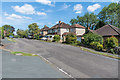
Oaks Close
Cul-de-sac first developed in the c1930s when it ended at a turning circle, which old maps suggest coincided with what would at first glance now appear to be passing places, as seen here. The houses beyond are later and are on the land of a large house on Kingston Road called Oak Hall (previously Hill Side).
Image: © Ian Capper
Taken: 5 Sep 2019
0.05 miles