IMAGES TAKEN NEAR TO
Oaks Close, LEATHERHEAD, KT22 7SH
Introduction
This page details the photographs taken nearby to Oaks Close, KT22 7SH by members of the Geograph project.
The Geograph project started in 2005 with the aim of publishing, organising and preserving representative images for every square kilometre of Great Britain, Ireland and the Isle of Man.

There are currently over 7.5m images from over14,400 individuals and you can help contribute to the project by visiting https://www.geograph.org.uk
Image Map
Images are licensed for reuse under creativecommons.org/licenses/by-sa/2.0
Notes
- Clicking on the map will re-center to the selected point.
- The higher the marker number, the further away the image location is from the centre of the postcode.
Image Listing (188 Images Found)
Images are licensed for reuse under creativecommons.org/licenses/by-sa/2.0
Image
Details
Distance
1
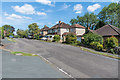
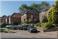
Oaks Close
Cul-de-sac first developed in the c1930s when it ended at a turning circle, which old maps suggest coincided with what would at first glance now appear to be passing places, as seen here. The houses beyond are later and are on the land of a large house on Kingston Road called Oak Hall (previously Hill Side).
Image: © Ian Capper
Taken: 5 Sep 2019
0.02 miles
2
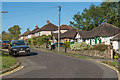
Oaks Close
Cul-de-sac of which the southern section, seen here, was first developed in the c1930s, before later being extended northwards.
Image: © Ian Capper
Taken: 13 Sep 2019
0.03 miles
3
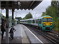
The Dorking train enters Leatherhead station
Image: © David Howard
Taken: 18 Aug 2008
0.04 miles
5
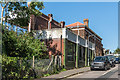
Kingston Road
c1940/50s housing on Kingston Road, built on the land of a large house on called Oak Hall (previously Hill Side).
Image: © Ian Capper
Taken: 18 Sep 2019
0.05 miles
6
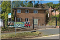
ACF Hut, Oaks Close
Base for the Leatherhead detachment of Surrey Army Cadets.
Image: © Ian Capper
Taken: 18 Sep 2019
0.05 miles
7
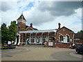
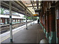
Leatherhead Station
Opened in 1867 by the London Brighton and South Coast Railway when they extended their railway (which had previously terminated by Kingston Road) south to Dorking and Horsham. It was designed by Charles Driver. These are the buildings on the down side (see Image for the main buildings, situated on the "up" side of the station). Grade II listed - see www.historicengland.org.uk/listing/the-list/list-entry/1191033.
The low building in the foreground is a later addition, with maps suggesting it was added in the first part of the 20th Century. It now houses an architects' practice.
Image: © Ian Capper
Taken: 18 Sep 2019
0.05 miles
9
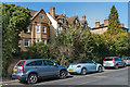
27a and 29 - 31 Kingston Road
Two houses on Kingston Road. Nos 29 - 31, on the left, is a pair of semi-detached Victorian houses marked on the 1869 1:2,500 map. No 27a is much more recent.
Image: © Ian Capper
Taken: 18 Sep 2019
0.06 miles
10
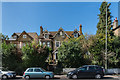
27a and 29 - 31 Kingston Road
Two houses on Kingston Road. Nos 29 - 31, on the left, is a pair of semi-detached Victorian houses marked on the 1869 1:2,500 map. No 27a is much more recent.
Image: © Ian Capper
Taken: 18 Sep 2019
0.06 miles