IMAGES TAKEN NEAR TO
Clements Mead, LEATHERHEAD, KT22 7RW
Introduction
This page details the photographs taken nearby to Clements Mead, KT22 7RW by members of the Geograph project.
The Geograph project started in 2005 with the aim of publishing, organising and preserving representative images for every square kilometre of Great Britain, Ireland and the Isle of Man.

There are currently over 7.5m images from over14,400 individuals and you can help contribute to the project by visiting https://www.geograph.org.uk
Image Map
Images are licensed for reuse under creativecommons.org/licenses/by-sa/2.0
Notes
- Clicking on the map will re-center to the selected point.
- The higher the marker number, the further away the image location is from the centre of the postcode.
Image Listing (53 Images Found)
Images are licensed for reuse under creativecommons.org/licenses/by-sa/2.0
Image
Details
Distance
1
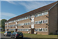
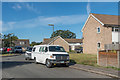
Clements Mead
Early 1960s housing estate off Kingston Road.
Image: © Ian Capper
Taken: 13 Sep 2019
0.02 miles
2
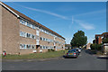
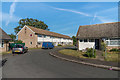
Clements Mead
Early 1960s housing estate off Kingston Road.
Image: © Ian Capper
Taken: 13 Sep 2019
0.03 miles
3
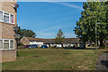
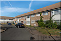
Clements Mead
Early 1960s housing estate off Kingston Road.
Image: © Ian Capper
Taken: 13 Sep 2019
0.03 miles
4
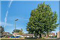
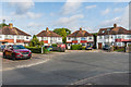
Clements Mead
Early 1960s housing estate off Kingston Road.
Image: © Ian Capper
Taken: 13 Sep 2019
0.03 miles
5
Clements Mead
Early 1960s housing estate off Kingston Road.
Image: © Ian Capper
Taken: 13 Sep 2019
0.04 miles
6
Clements Mead
Early 1960s housing estate off Kingston Road.
Image: © Ian Capper
Taken: 13 Sep 2019
0.04 miles
7
Clements Mead
Early 1960s housing estate off Kingston Road.
Image: © Ian Capper
Taken: 13 Sep 2019
0.06 miles
8
Albany Park Road
c1930s housing in a cul-de-sac at the end of Dilston Road.
Image: © Ian Capper
Taken: 30 Jul 2019
0.07 miles
9
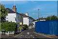
Oak Road
Crescent off Kingston Road. The two pairs of houses are late Victorian. The boarded off area on the right is the site of the Royal Oak pub which was illegally demolished by it owners in 2017. This pub dated from the early 1900s, replacing a previous pub of the same name which had been situated on the opposite side of Oak Road, beyond the two houses here.
Image: © Ian Capper
Taken: 13 Sep 2019
0.07 miles
10
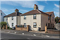
253 - 259 Kingston Road
Two pairs of semi-detached houses on Kingston Road, marked on the 1869 1:2,500 map.
Image: © Ian Capper
Taken: 13 Sep 2019
0.08 miles