IMAGES TAKEN NEAR TO
Clare Crescent, LEATHERHEAD, KT22 7RF
Introduction
This page details the photographs taken nearby to Clare Crescent, KT22 7RF by members of the Geograph project.
The Geograph project started in 2005 with the aim of publishing, organising and preserving representative images for every square kilometre of Great Britain, Ireland and the Isle of Man.

There are currently over 7.5m images from over14,400 individuals and you can help contribute to the project by visiting https://www.geograph.org.uk
Image Map (Loading...)


Getting Data...Please wait
Leaflet Map data © OpenStreetMap
Images are licensed for reuse under creativecommons.org/licenses/by-sa/2.0
Notes
- Clicking on the map will re-center to the selected point.
- The higher the marker number, the further away the image location is from the centre of the postcode.
Image Listing (62 Images Found)
Images are licensed for reuse under creativecommons.org/licenses/by-sa/2.0
Image
Details
Distance
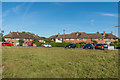
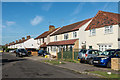
1
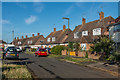
Clare Crescent
Part of an area of post Second World War housing east of Kingston Road.
Image: © Ian Capper
Taken: 13 Sep 2019
0.01 miles
2
Clare Crescent
Part of an area of post Second World War housing east of Kingston Road.
Image: © Ian Capper
Taken: 13 Sep 2019
0.04 miles
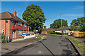
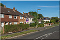
3
The Fairway
Part of an area of post Second World War housing east of Kingston Road.
Image: © Ian Capper
Taken: 13 Sep 2019
0.05 miles
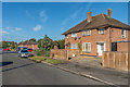
4
Sandes Place
Part of an area of post Second World War housing east of Kingston Road.
Image: © Ian Capper
Taken: 13 Sep 2019
0.08 miles
5
The Fairway
Part of an area of post Second World War housing east of Kingston Road.
Image: © Ian Capper
Taken: 13 Sep 2019
0.09 miles
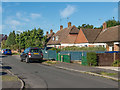
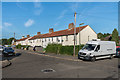
6
Aperdele Road
Part of an area of post Second World War housing east of Kingston Road. The name Aperdele refers to a family once connected to the Thorncroft estate south of Leatherhead.
Image: © Ian Capper
Taken: 13 Sep 2019
0.11 miles
7
Woodbridge Avenue
c1920s/30s housing east of Kingston Road.
Image: © Ian Capper
Taken: 13 Sep 2019
0.12 miles
8
Woodbridge Avenue
c1920s/30s housing east of Kingston Road.
Image: © Ian Capper
Taken: 13 Sep 2019
0.12 miles
9
Woodbridge Avenue
c1920s/30s housing east of Kingston Road.
Image: © Ian Capper
Taken: 13 Sep 2019
0.12 miles
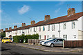
10
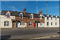
283 - 291 Kingston Road
Late Victorian terrace on Kingston Road.
Image: © Ian Capper
Taken: 13 Sep 2019
0.12 miles