IMAGES TAKEN NEAR TO
Kingston Road, LEATHERHEAD, KT22 7QE
Introduction
This page details the photographs taken nearby to Kingston Road, KT22 7QE by members of the Geograph project.
The Geograph project started in 2005 with the aim of publishing, organising and preserving representative images for every square kilometre of Great Britain, Ireland and the Isle of Man.

There are currently over 7.5m images from over14,400 individuals and you can help contribute to the project by visiting https://www.geograph.org.uk
Image Map
Images are licensed for reuse under creativecommons.org/licenses/by-sa/2.0
Notes
- Clicking on the map will re-center to the selected point.
- The higher the marker number, the further away the image location is from the centre of the postcode.
Image Listing (78 Images Found)
Images are licensed for reuse under creativecommons.org/licenses/by-sa/2.0
Image
Details
Distance
1
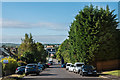
Kingston Road
Looking down Kingston Road from near where it was truncated by the building of the M25 in 1985.
Image: © Ian Capper
Taken: 13 Sep 2019
0.02 miles
2
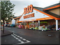
B and Q Leatherhead
The superstore off Oxshott Road, near junction 9 of the M25.
Image: © Gordon Griffiths
Taken: 23 Apr 2011
0.04 miles
3
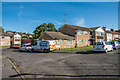
Ryebrook Road
Housing in a road largely developed in the c1920s/30s, although the flats seen here were added in the c1970s.
Image: © Ian Capper
Taken: 13 Sep 2019
0.05 miles
4
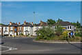
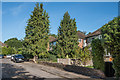
Kingston Road
Turn of the 19th/20th Centuries semi-detached villas on Kingston Road by its junction with Oxshott Road. Originally the A243 out of Leatherhead, the section of Kingston Road off to the left is now a stub, truncated as part of the reorganisation of roads in the immediate area on the opening of junction 9 of the M25 in 1985.
Image: © Ian Capper
Taken: 16 Jul 2019
0.05 miles
5
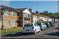
Ryebrook Road
Housing in a road largely developed in the c1920s/30s. The flats on the left were added in the c1970s.
Image: © Ian Capper
Taken: 13 Sep 2019
0.06 miles
6
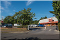
B&Q
DIY superstore on Kingston Road by its junction with Oxshott Road. On the left is part of the Tesco superstore the other side of Oxshott Road.
Image: © Ian Capper
Taken: 13 Sep 2019
0.06 miles
7
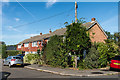
Ryebridge Close
Post Second World War maisonettes east of Kingston Road.
Image: © Ian Capper
Taken: 13 Sep 2019
0.06 miles
8
Ryebrook Road
Housing in a road largely developed in the c1920s/30s, although these houses were added in around the early 1960s.
Image: © Ian Capper
Taken: 13 Sep 2019
0.06 miles
9
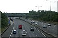
M25, J9
Taken from the footbridge over the M25 at junction 9 anti-clockwise. The junction for the clockwise carriageway is about a mile away!
Image: © Ben Gamble
Taken: 9 Jul 2005
0.07 miles
10
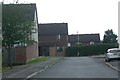
Teazlewood Park
Housing has inevitably encroached right up to the edge of the motorway here in Leatherhead.
Image: © Ben Gamble
Taken: 9 Jul 2005
0.07 miles