IMAGES TAKEN NEAR TO
Albany Park Road, LEATHERHEAD, KT22 7PA
Introduction
This page details the photographs taken nearby to Albany Park Road, KT22 7PA by members of the Geograph project.
The Geograph project started in 2005 with the aim of publishing, organising and preserving representative images for every square kilometre of Great Britain, Ireland and the Isle of Man.

There are currently over 7.5m images from over14,400 individuals and you can help contribute to the project by visiting https://www.geograph.org.uk
Image Map
Images are licensed for reuse under creativecommons.org/licenses/by-sa/2.0
Notes
- Clicking on the map will re-center to the selected point.
- The higher the marker number, the further away the image location is from the centre of the postcode.
Image Listing (60 Images Found)
Images are licensed for reuse under creativecommons.org/licenses/by-sa/2.0
Image
Details
Distance
1
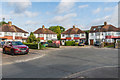
Albany Park Road
c1930s housing in a cul-de-sac at the end of Dilston Road.
Image: © Ian Capper
Taken: 30 Jul 2019
0.03 miles
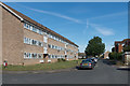
2
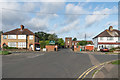
Dilston Road
c1930s housing in a road off Kingston Road. In the background is Therfield School - see Image
Image: © Ian Capper
Taken: 30 Jul 2019
0.04 miles
3
Dilston Road
c1930s housing in a road off Kingston Road. In the left background is Therfield School - see Image
Image: © Ian Capper
Taken: 30 Jul 2019
0.04 miles
4
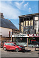
207 Kingston Road
Part of a short shopping parade in Kingston Road. The flat above the shop had been gutted by a fire on 28 May 2019.
Image: © Ian Capper
Taken: 13 Sep 2019
0.07 miles
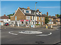
5
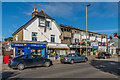
203 - 211 Kingston Road
Parade of shops on Kingston Road. Old maps suggest that the house on the left is late 19th Century, with the parade itself built in the 1960s/70s. The flat above no 207, at the left hand end of the parade, had been gutted by a fire on 28 May 2019.
Image: © Ian Capper
Taken: 13 Sep 2019
0.07 miles
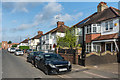
6
189 - 195 Kingston Road
Two pairs of late 19th Century semi-detached cottages on Kingston Road.
Image: © Ian Capper
Taken: 13 Sep 2019
0.07 miles
7
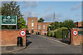
Therfield School
Secondary school in Dilston Road. Originally situated in Woodvill Road, where it started in 1913, where Leatherhead Trinity School & Children's Centre is now based, it moved to its present site in 1953. The name Therfield School was adopted in 1964 in recognition of the site being on land presented to a Brian de Therfield by King John in 1203.
Image: © Ian Capper
Taken: 30 Jul 2019
0.08 miles
9
Clements Mead
Early 1960s housing estate off Kingston Road.
Image: © Ian Capper
Taken: 13 Sep 2019
0.08 miles
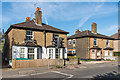
10
181 - 187 Kingston Road
Short turn of the 19th/20th Century terrace on Kingston Road by its junction with Dilston Road.
Image: © Ian Capper
Taken: 13 Sep 2019
0.08 miles