IMAGES TAKEN NEAR TO
Kingston Road, LEATHERHEAD, KT22 7NT
Introduction
This page details the photographs taken nearby to Kingston Road, KT22 7NT by members of the Geograph project.
The Geograph project started in 2005 with the aim of publishing, organising and preserving representative images for every square kilometre of Great Britain, Ireland and the Isle of Man.

There are currently over 7.5m images from over14,400 individuals and you can help contribute to the project by visiting https://www.geograph.org.uk
Image Map
Images are licensed for reuse under creativecommons.org/licenses/by-sa/2.0
Notes
- Clicking on the map will re-center to the selected point.
- The higher the marker number, the further away the image location is from the centre of the postcode.
Image Listing (108 Images Found)
Images are licensed for reuse under creativecommons.org/licenses/by-sa/2.0
Image
Details
Distance
1
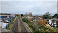
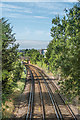
Railway line towards Leatherhead Station
Photo taken from the railway bridge for the Kingston Road which was a part of an improved road becoming the B2430. The original road was a narrow windy road with a railway crossing.
Image: © James Emmans
Taken: 18 Nov 2021
0.03 miles
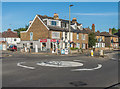
2
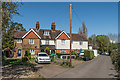
123 - 127 Kingston Road
Late 19th/early 20th Century three house terrace off Kingston Road.
Image: © Ian Capper
Taken: 10 Apr 2019
0.03 miles
3

Industrial area off Kingston Road
A small industrial area of triangular shape, sandwiched between the railway line and Kingston Road. The blue and white sign in the distance is that of Leatherhead Hand Car Wash.
Image: © P L Chadwick
Taken: 14 Aug 2010
0.08 miles
4
Buffers Lane
Cul-de-sac off Kingston Road. The name commemorates the first Leatherhead railway station which was situated where the houses in the background now stand. The station had opened on 1 February 1859 when the Epsom and Leatherhead Railway had a terminus here. Following the extension of the railway to Dorking and Horsham by the London Brighton and South Coast Railway in 1867, to link with the mid-Sussex line there, the station was closed with both the LB&SCR and London and South Western Railway (which had by then taken over the Epsom and Leatherhead Railway) opening their own separate stations nearer the town centre.
Image: © Ian Capper
Taken: 13 Sep 2019
0.08 miles
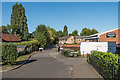
6
Leatherhead Community Hub
Located beside Kingston Road.
Image: © Peter Trimming
Taken: 21 Dec 2021
0.09 miles
7
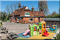
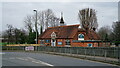
North Leatherhead Community Centre and Social Club
Community centre on Kingston Road housed in the building of the All Saints' Infants' School, built in 1900 and which closed in 1976 as part of the merger into Leatherhead Trinity School. Among the building's uses are as a nursery, hence the play equipment in the foreground.
Image: © Ian Capper
Taken: 10 Apr 2019
0.09 miles
8
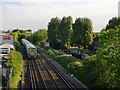
View south from the Kingston Road railway bridge
The train's next stop - in a minute or two - will be at Leatherhead.
Image: © Stefan Czapski
Taken: 27 May 2013
0.09 miles
9
Site of first Leatherhead Station
The site of the first railway station in Leatherhead north of Kingston Road, opened on 1 February 1859 when the Epsom and Leatherhead Railway had a terminus here. Following the extension of the railway to Dorking and Horsham by the London Brighton and South Coast Railway in 1867, to link with the mid-Sussex line there, the station was closed with both the LB&SCR and London and South Western Railway (which had by then taken over the Epsom and Leatherhead Railway) opening their own separate stations nearer the town centre.
Image: © Ian Capper
Taken: 13 Sep 2019
0.09 miles
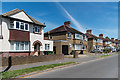
10
181 - 187 Kingston Road
Short turn of the 19th/20th Century terrace on Kingston Road by its junction with Dilston Road.
Image: © Ian Capper
Taken: 13 Sep 2019
0.09 miles