IMAGES TAKEN NEAR TO
Gaveston Road, LEATHERHEAD, KT22 7NR
Introduction
This page details the photographs taken nearby to Gaveston Road, KT22 7NR by members of the Geograph project.
The Geograph project started in 2005 with the aim of publishing, organising and preserving representative images for every square kilometre of Great Britain, Ireland and the Isle of Man.

There are currently over 7.5m images from over14,400 individuals and you can help contribute to the project by visiting https://www.geograph.org.uk
Image Map
Images are licensed for reuse under creativecommons.org/licenses/by-sa/2.0
Notes
- Clicking on the map will re-center to the selected point.
- The higher the marker number, the further away the image location is from the centre of the postcode.
Image Listing (91 Images Found)
Images are licensed for reuse under creativecommons.org/licenses/by-sa/2.0
Image
Details
Distance
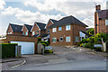
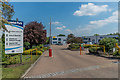
1
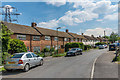
Gaveston Road
1950s housing in an area off Cleeve Road.
Image: © Ian Capper
Taken: 16 May 2019
0.02 miles
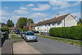
2
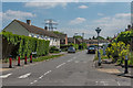
Gaveston Road
1950s housing in an area off Cleeve Road.
Image: © Ian Capper
Taken: 16 May 2019
0.02 miles
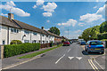
3
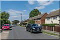
Randalls Crescent
1950s housing in an area off Cleeve Road.
Image: © Ian Capper
Taken: 16 May 2019
0.04 miles
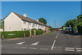
4
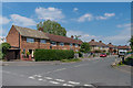
Randalls Park Avenue
1950s housing in an area off Cleeve Road.
Image: © Ian Capper
Taken: 16 May 2019
0.05 miles
5
Tilney Close
Short cul-de-sac off Randalls Crescent.
Image: © Ian Capper
Taken: 16 May 2019
0.06 miles
6
Gaveston Road
1950s housing in an area off Cleeve Road.
Image: © Ian Capper
Taken: 16 May 2019
0.06 miles
7
Randalls Crescent
1950s housing in an area off Cleeve Road.
Image: © Ian Capper
Taken: 16 May 2019
0.06 miles
8
Randalls Crescent
1950s housing off Cleeve Road.
Image: © Ian Capper
Taken: 26 May 2017
0.07 miles
9
Imperial Park
Business units on Randalls Way.
Image: © Ian Capper
Taken: 16 May 2019
0.07 miles
10
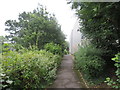
Public footpath, Leatherhead
A public footpath in Leatherhead, in Surrey.
Image: © Malc McDonald
Taken: 28 Jul 2019
0.08 miles