IMAGES TAKEN NEAR TO
Cleeve Road, LEATHERHEAD, KT22 7NH
Introduction
This page details the photographs taken nearby to Cleeve Road, KT22 7NH by members of the Geograph project.
The Geograph project started in 2005 with the aim of publishing, organising and preserving representative images for every square kilometre of Great Britain, Ireland and the Isle of Man.

There are currently over 7.5m images from over14,400 individuals and you can help contribute to the project by visiting https://www.geograph.org.uk
Image Map
Images are licensed for reuse under creativecommons.org/licenses/by-sa/2.0
Notes
- Clicking on the map will re-center to the selected point.
- The higher the marker number, the further away the image location is from the centre of the postcode.
Image Listing (71 Images Found)
Images are licensed for reuse under creativecommons.org/licenses/by-sa/2.0
Image
Details
Distance
1
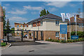
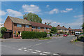
Thornton Close
Small development off Cleeve Road completed in early 2019.
Image: © Ian Capper
Taken: 16 May 2019
0.02 miles
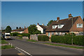
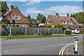
2
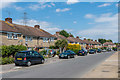
Cleeve Road
1950s housing on Cleeve Road.
Image: © Ian Capper
Taken: 16 May 2019
0.03 miles
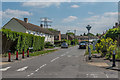
3
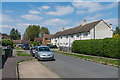
Gaveston Road
1950s housing in an area off Cleeve Road.
Image: © Ian Capper
Taken: 16 May 2019
0.03 miles
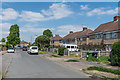
5
Randalls Park Avenue
1950s housing in an area off Cleeve Road.
Image: © Ian Capper
Taken: 16 May 2019
0.04 miles
7
Gaveston Road
1950s housing in an area off Cleeve Road.
Image: © Ian Capper
Taken: 16 May 2019
0.06 miles
8
Long Shaw
1950s housing in an area off Cleeve Road.
Image: © Ian Capper
Taken: 16 May 2019
0.07 miles
9
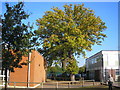
Grounds of Therfield School, Leatherhead
With a fine maple just beginning to show its autumn tints
Image: © Dr Neil Clifton
Taken: 21 Oct 2007
0.07 miles
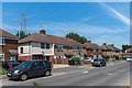
10
Cleeve Road
1950s housing on Cleeve Road.
Image: © Ian Capper
Taken: 16 May 2019
0.08 miles