IMAGES TAKEN NEAR TO
Grange Road, LEATHERHEAD, KT22 7JS
Introduction
This page details the photographs taken nearby to Grange Road, KT22 7JS by members of the Geograph project.
The Geograph project started in 2005 with the aim of publishing, organising and preserving representative images for every square kilometre of Great Britain, Ireland and the Isle of Man.

There are currently over 7.5m images from over14,400 individuals and you can help contribute to the project by visiting https://www.geograph.org.uk
Image Map
Images are licensed for reuse under creativecommons.org/licenses/by-sa/2.0
Notes
- Clicking on the map will re-center to the selected point.
- The higher the marker number, the further away the image location is from the centre of the postcode.
Image Listing (18 Images Found)
Images are licensed for reuse under creativecommons.org/licenses/by-sa/2.0
Image
Details
Distance
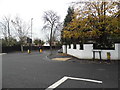
1
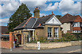
The Gate Lodge
Lodge to the former Ashtead Grange on Ottways Lane. The date on the gable is 1895, although Ashtead Grange itself dated from earlier.
Image: © Ian Capper
Taken: 7 Sep 2018
0.05 miles
2
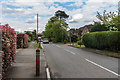
Ottway's Lane
Former lane, with this section built up in around the 1930s.
Image: © Ian Capper
Taken: 28 Apr 2017
0.07 miles
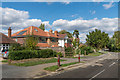
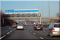
5
Ermyn Way at the junction of Leatherhead Road
Image: © David Howard
Taken: 16 Nov 2014
0.20 miles
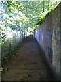
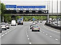
6
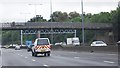
Footbridge over the M25, near junction 9
Image: © N Chadwick
Taken: 23 Aug 2010
0.20 miles
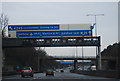
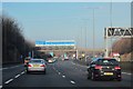
10
Junction 9 (Leatherhead Junction), Clockwise M25
Image: © David Dixon
Taken: 17 May 2013
0.21 miles