IMAGES TAKEN NEAR TO
Linden Court, LEATHERHEAD, KT22 7JG
Introduction
This page details the photographs taken nearby to Linden Court, KT22 7JG by members of the Geograph project.
The Geograph project started in 2005 with the aim of publishing, organising and preserving representative images for every square kilometre of Great Britain, Ireland and the Isle of Man.

There are currently over 7.5m images from over14,400 individuals and you can help contribute to the project by visiting https://www.geograph.org.uk
Image Map (Loading...)


Getting Data...Please wait
Leaflet Map data © OpenStreetMap
Images are licensed for reuse under creativecommons.org/licenses/by-sa/2.0
Notes
- Clicking on the map will re-center to the selected point.
- The higher the marker number, the further away the image location is from the centre of the postcode.
Image Listing (361 Images Found)
Images are licensed for reuse under creativecommons.org/licenses/by-sa/2.0
Image
Details
Distance
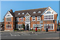
1
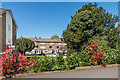
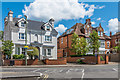
Linden Court
Flats by the junction of Epsom Road and Leret Way, built around 1960 on the site of a large house, Linden House.
Image: © Ian Capper
Taken: 10 Apr 2019
0.01 miles
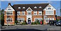
2
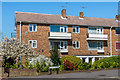
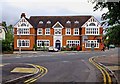
Linden Court
Flats by the junction of Epsom Road and Leret Way, built around 1960 on the site of a large house, Linden House.
Image: © Ian Capper
Taken: 10 Apr 2019
0.03 miles
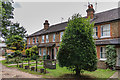
3
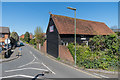
Linden Road
Looking along Linden Road from Leret Way. The converted barn is thought to date from around 1600.
Image: © Ian Capper
Taken: 10 Apr 2019
0.03 miles
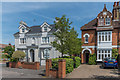
4
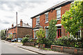
Linden Road
Turn of the 19th/20th Century houses in Linden Road.
Image: © Ian Capper
Taken: 6 Aug 2019
0.06 miles
5
The Leatherhead Institute
Hall opened in 1892 and funded by Abraham Dixon of Cherkley Court to provide them with educational, social and recreational facilities. It is now run by a charity, the Leatherhead Community Association.
Image: © Ian Capper
Taken: 10 Apr 2019
0.06 miles
6
1 and 3 Church Road
Buildings at the north end of Church Road. No 1 (forming part of Denver Court) is a sympathetic replacement of a late Victorian villa (see Image for the original before demolition) while no 3 (a semidetached part of a pair) is early 20th Century.
Image: © Ian Capper
Taken: 15 May 2019
0.06 miles
7
Leatherhead - Institute
Late Victorian building (1892) that carries the old spelling Letherhead Institute. It was built in 1892 by local benefactor Abraham Dixon of Cherkley Court.
Image: © Colin Smith
Taken: 28 Sep 2015
0.06 miles
8
Queen Anne's Gardens
Early 20th Century terrace in a road off in Linden Road. The date plaque in the centre of the terrace gives a building year of 1903.
Image: © Ian Capper
Taken: 6 Aug 2019
0.06 miles
9
1 and 3 - 5 Church Road
Buildings at the north end of Church Road. No 1 (forming part of Denver Court) is a sympathetic replacement of a late Victorian villa (see Image for the original before demolition) while nos 3 - 5 is early 20th Century.
Image: © Ian Capper
Taken: 6 Jun 2019
0.06 miles
10
Leatherhead (formerly Letherhead) Institute, 67 High Street
The building dates from 1892, when the town's name was spelt without an "a" after the first "e". It was provided by a local benefactor Abraham Dixon, of Cherkley Court. He gave the Institute to provide educational, social and recreational facilities for local people. Today the Leatherhead Community Association continue to deliver Abraham Dixon's aims, in co-operation with the charitable trust, which owns the building. There are a range of activities and facilities provided here.
Image
Image: © P L Chadwick
Taken: 14 Aug 2010
0.06 miles