IMAGES TAKEN NEAR TO
KT22 7HJ
Introduction
This page details the photographs taken nearby to KT22 7HJ by members of the Geograph project.
The Geograph project started in 2005 with the aim of publishing, organising and preserving representative images for every square kilometre of Great Britain, Ireland and the Isle of Man.

There are currently over 7.5m images from over14,400 individuals and you can help contribute to the project by visiting https://www.geograph.org.uk
Image Map
Images are licensed for reuse under creativecommons.org/licenses/by-sa/2.0
Notes
- Clicking on the map will re-center to the selected point.
- The higher the marker number, the further away the image location is from the centre of the postcode.
Image Listing (461 Images Found)
Images are licensed for reuse under creativecommons.org/licenses/by-sa/2.0
Image
Details
Distance
1
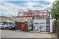
New flats
New flats under construction in Upper Fairfield Road, on the site of the former Fairfield Works.
Image: © Ian Capper
Taken: 6 Aug 2019
0.02 miles
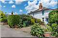
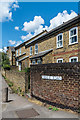
2
26 Middle Road
Late 18th/early 19th Century house in Middle Road. Grade II listed - see www.historicengland.org.uk/listing/the-list/list-entry/1378207.
Image: © Ian Capper
Taken: 6 Jun 2019
0.02 miles
3

26 Middle Road
Late 18th/early 19th Century house in Middle Road. Grade II listed - see www.historicengland.org.uk/listing/the-list/list-entry/1378207.
Image: © Ian Capper
Taken: 6 Jun 2019
0.02 miles
4
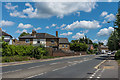
Leret Way
Inner bypass of Leatherhead town centre, cut through in the 1970s. Leret is the historic name of Leatherhead.
Image: © Ian Capper
Taken: 6 Jun 2019
0.02 miles
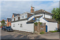
5
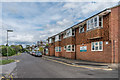
28 - 30 Middle Road
Pair of semi-detached houses in Middle Road.
Image: © Ian Capper
Taken: 6 Jun 2019
0.03 miles
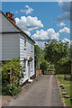
7
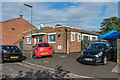
Linden House
Joint residential and doctors' surgery in Upper Fairfield Road.
Image: © Ian Capper
Taken: 6 Aug 2019
0.03 miles
8
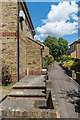
Middle Road
Narrow lane, now a footpath at its southern end where it meets Leret Way.
Image: © Ian Capper
Taken: 6 Jun 2019
0.03 miles
9
Little Oaks Children's Nursery
Children's nursery operating in a former Royal British Legion club.
Image: © Ian Capper
Taken: 7 Aug 2019
0.03 miles
10
36 - 38 Upper Fairfield Road
Weatherboarded building in Upper Fairfield Road, which maps suggest dated originally from the mid 19th Century or earlier.
Image: © Ian Capper
Taken: 7 Aug 2019
0.04 miles