IMAGES TAKEN NEAR TO
Station Road, LEATHERHEAD, KT22 7FG
Introduction
This page details the photographs taken nearby to Station Road, KT22 7FG by members of the Geograph project.
The Geograph project started in 2005 with the aim of publishing, organising and preserving representative images for every square kilometre of Great Britain, Ireland and the Isle of Man.

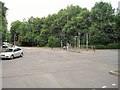
There are currently over 7.5m images from over14,400 individuals and you can help contribute to the project by visiting https://www.geograph.org.uk
Image Map
Images are licensed for reuse under creativecommons.org/licenses/by-sa/2.0
Notes
- Clicking on the map will re-center to the selected point.
- The higher the marker number, the further away the image location is from the centre of the postcode.
Image Listing (351 Images Found)
Images are licensed for reuse under creativecommons.org/licenses/by-sa/2.0
Image
Details
Distance
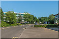
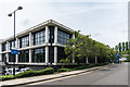
1

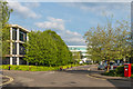
Leatherhead House
Office block in Mole Business Park. Originally built in the 1990s, it underwent a "back to frame" refurbishment in around 2006.
Image: © Ian Capper
Taken: 26 May 2017
0.02 miles
2
Station Approach
Part of the Leatherhead gyratory system. The wall on the left was originally the retaining wall below the former London and South Western Railway station. This closed in 1927 following the grouping in 1923 which resulted in both that railway and the London Brighton and South Coast Railway both becoming part of the Southern Railway, with the former LB&SCR's station being retained. The L&SWR site continued to be used for many years for carriage sidings, eventually removed in around the 1960s.
Image: © Ian Capper
Taken: 10 Apr 2019
0.03 miles
3
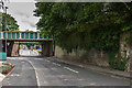
Bridges over Station Road
Railway bridges over Station Road, by the exit from Mole Business Park, south of Leatherhead Station. Just visible in the background is that carrying the line to Dorking, and in front of it is that carrying the line to Effingham Junction and Guildford. The latter route dates from 1927 when following the grouping in 1923 the former L&SWR station was closed with all trains using the former LB&SCR station instead. This required a new spur to be built for the Guildford line including the bridge; the wall on the right in this photo is part of the abutment for the bridge on the original route.
Image: © Ian Capper
Taken: 6 Aug 2019
0.03 miles
4
Old Station Approach
Unit on Old Station Approach built on the site of the former London and South Western Railway station which closed in 1927 when services were diverted into the current Leatherhead Station, previously used only by London Brighton and South Coast Railway trains. In the background is Leatherhead House.
Image: © Ian Capper
Taken: 3 Oct 2019
0.04 miles
5
Mole Business Park
Road through Mole Business Park, also giving access to Leatherhead Industrial Estate.
Image: © Ian Capper
Taken: 26 May 2017
0.04 miles
6
Leatherhead L&SWR station (site), Surrey
Opened in 1867 by the London & South Western Railway as the terminus of a short branch from Effingham Junction, this station closed in 1927 when services were diverted into the current station (just out-of-sight, to the left of the camera position), by the Southern Railway.
View south. The site is now hidden by a row of trees.
Image: © Nigel Thompson
Taken: 26 Jun 2015
0.04 miles
7
Mole Business Park
Offices in Mole Business Park, built on the site of the factory of Ronson, manufacturer of cigarette lighters, which was situated here from 1953 to 1981.
Image: © Ian Capper
Taken: 30 Apr 2019
0.05 miles
8
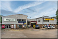
Leatherhead Industrial Estate
Commercial premises by the entrance to (but strictly speaking outside) Mole Business Park, off Station Road.
Image: © Ian Capper
Taken: 15 Aug 2019
0.05 miles
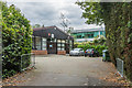
9
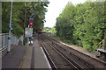
Leatherhead station south end
A train to Dorking can be seen in the distance. On the right is the line to Guildford
Image: © Robert Eva
Taken: 13 Jul 2017
0.06 miles
10
Mole Business Park
Unit in Mole Business Park, built on the site of the factory of Ronson, manufacturer of cigarette lighters, which was situated here from 1953 to 1981. This units houses the offices of Surrey and Borders Partnership NHS Foundation Trust.
Image: © Ian Capper
Taken: 17 Jul 2019
0.06 miles