IMAGES TAKEN NEAR TO
Levett Road, LEATHERHEAD, KT22 7EG
Introduction
This page details the photographs taken nearby to Levett Road, KT22 7EG by members of the Geograph project.
The Geograph project started in 2005 with the aim of publishing, organising and preserving representative images for every square kilometre of Great Britain, Ireland and the Isle of Man.

There are currently over 7.5m images from over14,400 individuals and you can help contribute to the project by visiting https://www.geograph.org.uk
Image Map
Images are licensed for reuse under creativecommons.org/licenses/by-sa/2.0
Notes
- Clicking on the map will re-center to the selected point.
- The higher the marker number, the further away the image location is from the centre of the postcode.
Image Listing (74 Images Found)
Images are licensed for reuse under creativecommons.org/licenses/by-sa/2.0
Image
Details
Distance
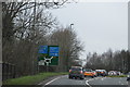
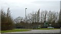
2
The Knoll roundabout, Leatherhead
Turn left for the shops and the station
Image: © David Howard
Taken: 20 Feb 2012
0.06 miles
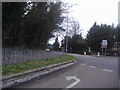
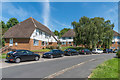
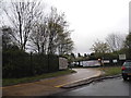
3
Levett Road
c1970s housing off Copthorne Road.
Image: © Ian Capper
Taken: 4 Jul 2019
0.06 miles
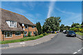
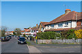
4
Levett Road
c1970s housing off Copthorne Road.
Image: © Ian Capper
Taken: 4 Jul 2019
0.07 miles
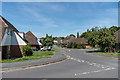
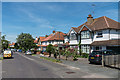
6
Cressall Mead
c1970s housing off Copthorne Road.
Image: © Ian Capper
Taken: 4 Jul 2019
0.09 miles
9
Entrance to the Department of Transport Depot, Leatherhead
Image: © David Howard
Taken: 7 Apr 2014
0.11 miles
10
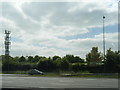
M25 at Junction 9 with mast to the south
Image: © Colin Pyle
Taken: 9 May 2017
0.11 miles