IMAGES TAKEN NEAR TO
Woodvill Road, LEATHERHEAD, KT22 7BP
Introduction
This page details the photographs taken nearby to Woodvill Road, KT22 7BP by members of the Geograph project.
The Geograph project started in 2005 with the aim of publishing, organising and preserving representative images for every square kilometre of Great Britain, Ireland and the Isle of Man.

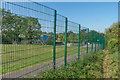
There are currently over 7.5m images from over14,400 individuals and you can help contribute to the project by visiting https://www.geograph.org.uk
Image Map
Images are licensed for reuse under creativecommons.org/licenses/by-sa/2.0
Notes
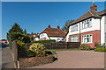
- Clicking on the map will re-center to the selected point.
- The higher the marker number, the further away the image location is from the centre of the postcode.
Image Listing (132 Images Found)
Images are licensed for reuse under creativecommons.org/licenses/by-sa/2.0
Image
Details
Distance
1
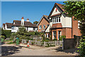
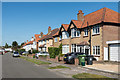
Woodville Road
Mainly Edwardian houses in a cul-de-sac off Kingston Road.
Image: © Ian Capper
Taken: 18 Sep 2019
0.01 miles
2
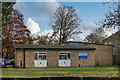
Ambulance Station
Leatherhead Ambulance Station on Kingston Road.
Image: © Ian Capper
Taken: 14 Nov 2019
0.05 miles
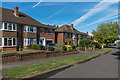
4
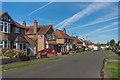
66 - 70 Kingston Road
Buildings on Kingston Road built in the 1920s/30s. The building on the left, no 70, now housing a sports shop and fitness centre, is marked on the 1963-4 1:2,500 map as a Co-operative Hall. From 1975 to 1987 it was the home of Surrey Sound Studios, set up by brothers Chris and Nigel Gray and used by a number of bands, including The Police, whose first two 2 albums, Outlandos d'Amour and Reggatta de Blanc were recorded here.
Image: © Ian Capper
Taken: 13 Sep 2019
0.06 miles
5
Footpath alongside Leatherhead Trinity School
Footpath connecting St John's Avenue and Kingston Road, seen here running alongside the grounds of Leatherhead Trinity School.
Image: © Ian Capper
Taken: 18 Sep 2019
0.06 miles
7
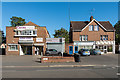
All Saints' Church Centre and 92 - 96 Kingston Road
All Saints' Church Centre was designed by Arthur Blomfield and consecrated as All Saints' Church on 23 February 1989. In 1981 it was re-ordered as a multi-purpose hall including a coffee shop, and rededicated as the All Saints Church Centre on 28 March 1982.
No 92 - 94 and 96 Kingston Road date from around the turn of the 19th/20th Centuries.
Image: © Ian Capper
Taken: 14 Nov 2019
0.07 miles
8
Kingscroft Road
Post war(?) southern extension to a c1930s cul-de-sac, this part being built on what was shown on the 1939 1:2,500 map as allotment gardens.
Image: © Ian Capper
Taken: 13 Sep 2019
0.07 miles
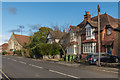
9
Kingston Road
c1930s housing on Kingston Road.
Image: © Ian Capper
Taken: 13 Sep 2019
0.07 miles
10

All Saints Church (1), Kingston Road
This Anglican church was built in 1889 to serve the population of the Leatherhead Common area. Like most churches it seems to have suffered a decline in attendance, as there are now normally only two services here a month. Some of the windows also appear to have been either partially or fully boarded up, so presumably there has been a problem with vandalism here.
Image
Image
Image: © P L Chadwick
Taken: 14 Aug 2010
0.07 miles