IMAGES TAKEN NEAR TO
Randalls Road, LEATHERHEAD, KT22 7AD
Introduction
This page details the photographs taken nearby to Randalls Road, KT22 7AD by members of the Geograph project.
The Geograph project started in 2005 with the aim of publishing, organising and preserving representative images for every square kilometre of Great Britain, Ireland and the Isle of Man.

There are currently over 7.5m images from over14,400 individuals and you can help contribute to the project by visiting https://www.geograph.org.uk
Image Map
Images are licensed for reuse under creativecommons.org/licenses/by-sa/2.0
Notes
- Clicking on the map will re-center to the selected point.
- The higher the marker number, the further away the image location is from the centre of the postcode.
Image Listing (194 Images Found)
Images are licensed for reuse under creativecommons.org/licenses/by-sa/2.0
Image
Details
Distance
1
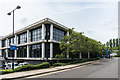
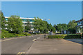
Mole Business Park
Unit in Mole Business Park, built on the site of the factory of Ronson, manufacturer of cigarette lighters, which was situated here from 1953 to 1981. This units houses the offices of Surrey and Borders Partnership NHS Foundation Trust.
Image: © Ian Capper
Taken: 17 Jul 2019
0.02 miles
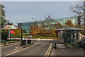
2
Ronson Way
Access road off Randalls Road into Mole Business Park, built on the site of the factory of Ronson, manufacturer of cigarette lighters, which was situated here from 1953 to 1981. In the background is the Police Federation's Federation House, on the opposite side of Randalls Road.
Image: © Ian Capper
Taken: 20 Nov 2019
0.02 miles
3
Mole Business Park
Offices in Mole Business Park, built on the site of the factory of Ronson, manufacturer of cigarette lighters, which was situated here from 1953 to 1981.
Image: © Ian Capper
Taken: 30 Apr 2019
0.03 miles
4
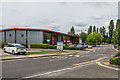
Mole Business Park
Units in Mole Business Park, built on the site of the factory of Ronson, manufacturer of cigarette lighters, which was situated here from 1953 to 1981.
Image: © Ian Capper
Taken: 17 Jul 2019
0.04 miles
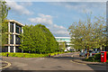
5
Mole Business Park
Road through Mole Business Park, also giving access to Leatherhead Industrial Estate.
Image: © Ian Capper
Taken: 26 May 2017
0.04 miles
6
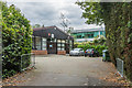
Old Station Approach
Unit on Old Station Approach built on the site of the former London and South Western Railway station which closed in 1927 when services were diverted into the current Leatherhead Station, previously used only by London Brighton and South Coast Railway trains. In the background is Leatherhead House.
Image: © Ian Capper
Taken: 3 Oct 2019
0.05 miles
7
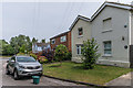
Railway Cottages
Pair of former railway cottages (with another pair in the background) in Old Station Approach. The road originally gave access to the London and South Western Railway station at Leatherhead which was closed following the grouping in 1923 when services to Guildford were transferred to the nearby former London Brighton and South Coast Railway station.
Image: © Ian Capper
Taken: 17 Jul 2019
0.05 miles
8
Ronson Way
Barriers at the end of Ronson Way, an access road off Randalls Road into Mole Business Park, built on the site of the factory of Ronson, manufacturer of cigarette lighters, which was situated here from 1953 to 1981. In the background is the Police Federation's Federation House, on the opposite side of Randalls Road.
Image: © Ian Capper
Taken: 20 Nov 2019
0.05 miles
9

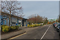
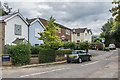
Leatherhead
Old Station Approach. The original station (now demolished) was opened by the London & South Western Railway in 1867. Some of the houses, in this picture, appear to date from that era.
The current railway station lies to the north of this location.
Image: © Peter Trimming
Taken: 21 Dec 2021
0.06 miles
10
Old Station Approach
Road originally giving access to the London and South Western Railway station at Leatherhead which was closed following the grouping in 1923 when services to Guildford were transferred to the nearby former London Brighton and South Coast Railway station. The cottages on the left and in the background are former railway cottages.
Image: © Ian Capper
Taken: 3 Oct 2019
0.06 miles