IMAGES TAKEN NEAR TO
Fairoak Lane, LEATHERHEAD, KT22 0TR
Introduction
This page details the photographs taken nearby to Fairoak Lane, KT22 0TR by members of the Geograph project.
The Geograph project started in 2005 with the aim of publishing, organising and preserving representative images for every square kilometre of Great Britain, Ireland and the Isle of Man.

There are currently over 7.5m images from over14,400 individuals and you can help contribute to the project by visiting https://www.geograph.org.uk
Image Map
Images are licensed for reuse under creativecommons.org/licenses/by-sa/2.0
Notes
- Clicking on the map will re-center to the selected point.
- The higher the marker number, the further away the image location is from the centre of the postcode.
Image Listing (14 Images Found)
Images are licensed for reuse under creativecommons.org/licenses/by-sa/2.0
Image
Details
Distance
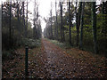
1
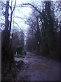
The Avenue, Oxshott
Private gated track leading to the A243 in Pachesham Park
Image: © David Howard
Taken: 19 Dec 2011
0.03 miles
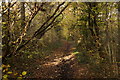
2
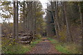
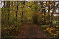
Track into Prince's Covert, Oxshott
Image: © Mike Pennington
Taken: 16 Nov 2017
0.04 miles
3
New Road byway
Heading north from Fairoak Lane.
Image: © Hugh Venables
Taken: 6 Nov 2010
0.05 miles
4
New Road (byway)
This byway runs northwards from Fairoak Lane to Claygate: this view looks north from the Fairoak Lane junction.
Image: © Andrew Longton
Taken: 8 Sep 2005
0.05 miles
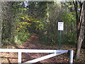
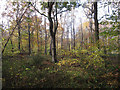
5
Track through Prince's Coverts
Access to Prince's Coverts is by permit only, but they are available free (except for a small key deposit).
Image: © Hugh Venables
Taken: 6 Nov 2010
0.06 miles
8
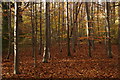
Beech trees in Limekiln Wood, Oxshott
Image: © Mike Pennington
Taken: 16 Nov 2017
0.17 miles
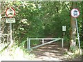
10
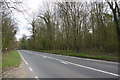
Fair Oak Lane
At this point Fair Oak lane (the B280 from Oxshott to Epsom) runs through Princes Coverts a large area of woodland east of Oxshott and south of Claygate.
Image: © Nigel Mykura
Taken: 17 Apr 2015
0.20 miles