IMAGES TAKEN NEAR TO
Hardwick Close, LEATHERHEAD, KT22 0HZ
Introduction
This page details the photographs taken nearby to Hardwick Close, KT22 0HZ by members of the Geograph project.
The Geograph project started in 2005 with the aim of publishing, organising and preserving representative images for every square kilometre of Great Britain, Ireland and the Isle of Man.

There are currently over 7.5m images from over14,400 individuals and you can help contribute to the project by visiting https://www.geograph.org.uk
Image Map
Images are licensed for reuse under creativecommons.org/licenses/by-sa/2.0
Notes
- Clicking on the map will re-center to the selected point.
- The higher the marker number, the further away the image location is from the centre of the postcode.
Image Listing (5 Images Found)
Images are licensed for reuse under creativecommons.org/licenses/by-sa/2.0
Image
Details
Distance
2
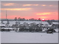
Mast at winter sunset
This view is from the bridleway from Wrens Hill looking across the fields towards Stoke d'Abernon.
Image: © CBL
Taken: 7 Jan 2010
0.15 miles
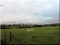
4
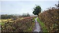
Bridle Lane Stoke D'Abernon
Viewing the Leatherhead Stoke D'Abernon DAB TV transmitter mast.
Image: © James Emmans
Taken: 6 Dec 2021
0.18 miles