IMAGES TAKEN NEAR TO
Pachesham Park, LEATHERHEAD, KT22 0DJ
Introduction
This page details the photographs taken nearby to Pachesham Park, KT22 0DJ by members of the Geograph project.
The Geograph project started in 2005 with the aim of publishing, organising and preserving representative images for every square kilometre of Great Britain, Ireland and the Isle of Man.

There are currently over 7.5m images from over14,400 individuals and you can help contribute to the project by visiting https://www.geograph.org.uk
Image Map
Images are licensed for reuse under creativecommons.org/licenses/by-sa/2.0
Notes
- Clicking on the map will re-center to the selected point.
- The higher the marker number, the further away the image location is from the centre of the postcode.
Image Listing (8 Images Found)
Images are licensed for reuse under creativecommons.org/licenses/by-sa/2.0
Image
Details
Distance
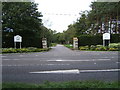
1
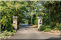
Driveway to Pachesham Park
Driveway off Oxshott Road, leading into Pachesham Park, an exclusive estate developed in the 20th Century (although the name is much older, Pachesham or Pachenesham being one of the ancient manors of Leatherhead).
Image: © Ian Capper
Taken: 16 Jul 2019
0.20 miles
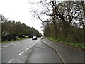
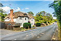
5
A243 Entrance to Leatherhead Golf Club
Image: © Roger Miller
Taken: 18 Sep 2005
0.22 miles
6
Lodges, Little Brook Park
Thatched entrance arch with lodges over the drive to Little Brook Park, a house that first appears on the 1938 1:10,000 map.
Image: © Ian Capper
Taken: 16 Jul 2019
0.23 miles
7
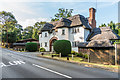
Lodges, Little Brook Park
Thatched entrance arch with lodges over the drive to Little Brook Park, a house that first appears on the 1938 1:10,000 map.
Image: © Ian Capper
Taken: 16 Jul 2019
0.23 miles
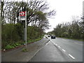
8
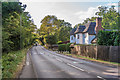
Oxshott Road
Looking along Oxshott Road towards its junction with Oaklawn Road. On the right is a thatched entrance arch with lodges over the drive to Little Brook Park, a house that first appears on the 1938 1:10,000 map.
Image: © Ian Capper
Taken: 16 Jul 2019
0.24 miles