IMAGES TAKEN NEAR TO
Woodlands Road, LEATHERHEAD, KT22 0AN
Introduction
This page details the photographs taken nearby to Woodlands Road, KT22 0AN by members of the Geograph project.
The Geograph project started in 2005 with the aim of publishing, organising and preserving representative images for every square kilometre of Great Britain, Ireland and the Isle of Man.

There are currently over 7.5m images from over14,400 individuals and you can help contribute to the project by visiting https://www.geograph.org.uk
Image Map
Images are licensed for reuse under creativecommons.org/licenses/by-sa/2.0
Notes
- Clicking on the map will re-center to the selected point.
- The higher the marker number, the further away the image location is from the centre of the postcode.
Image Listing (7 Images Found)
Images are licensed for reuse under creativecommons.org/licenses/by-sa/2.0
Image
Details
Distance
1
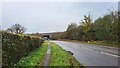
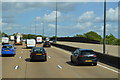
Woodland Road
The M25 passes over the semi-rural A245.
Image: © James Emmans
Taken: 6 Dec 2021
0.11 miles
2
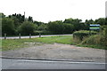
Junction of Randalls Road and Woodlands Road
Unsurfaced triangle of land at the junction of Randalls Road, Oaklawn Road and Woodlands Road. When the junction was first laid out under the Leatherhead Common inclosure award, soon after 1865, this area would have been available for traffic turning from Woodlands Road (then Stoke Road) into Oaklawn Road (then Patsham Green Road), but it has long since been left unpaved and more recently staked off, to improve road safety.
Image: © Hugh Craddock
Taken: 10 Aug 2013
0.15 miles
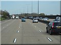
3
Randalls Road at the entrance to Pachesham Farm
Image: © David Howard
Taken: 1 Sep 2014
0.22 miles
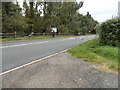
6
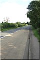
Randalls Road
Randalls Road just south of the junction with Oaklawn Road.
Image: © Hugh Craddock
Taken: 10 Aug 2013
0.23 miles