IMAGES TAKEN NEAR TO
Crampshaw Lane, ASHTEAD, KT21 2TZ
Introduction
This page details the photographs taken nearby to Crampshaw Lane, KT21 2TZ by members of the Geograph project.
The Geograph project started in 2005 with the aim of publishing, organising and preserving representative images for every square kilometre of Great Britain, Ireland and the Isle of Man.

There are currently over 7.5m images from over14,400 individuals and you can help contribute to the project by visiting https://www.geograph.org.uk
Image Map
Images are licensed for reuse under creativecommons.org/licenses/by-sa/2.0
Notes
- Clicking on the map will re-center to the selected point.
- The higher the marker number, the further away the image location is from the centre of the postcode.
Image Listing (15 Images Found)
Images are licensed for reuse under creativecommons.org/licenses/by-sa/2.0
Image
Details
Distance
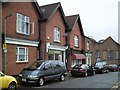
1
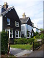
Gables in Ashtead
Attractive gabled cottages in the commuters' village of Ashtead.
Image: © Colin Smith
Taken: 29 May 2011
0.03 miles
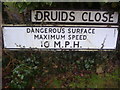
2
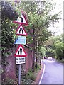
Signs, Rectory Lane, Ashtead
A narrow road, a high brick wall and a busy junction on a blind corner makes the southern end of Rectory Lane awkward to negotiate both in a car and on foot. Despite the numerous problems presented to the driver, this is still a heavily used rat-run, especially during the school run.
Image: © Thomas Grant
Taken: 10 May 2007
0.09 miles
3
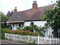
Howard Cottage
Historic timber-framed cottage in Ashtead, dating back to the early 17th century.
Image: © Colin Smith
Taken: 29 May 2011
0.10 miles
4
Chalk Lane
Private Roads and an upmarket residential area of large homes with large gardens close to Ashtead Downs.
Image: © Colin Smith
Taken: 29 May 2011
0.12 miles
5
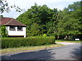
Crampshaw Lane
Leafy commuterdom on the downs at the southern edge of Ashtead village.
Image: © Colin Smith
Taken: 29 May 2011
0.15 miles
6

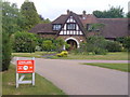
Ashtead Lodge
18th century mansion which used to be called Prospect Place when it had a view over the countryside to Leatherhead.
Image: © Colin Smith
Taken: 29 May 2011
0.15 miles
8
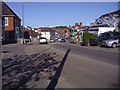
Ashtead town centre
Epsom Road looking from the west.
Image: © David Howard
Taken: 26 Apr 2009
0.20 miles
9
Rectory Lane, Ashtead
Long ago Rectory Lane was the principal commercial street in Ashtead. Over time, The Street has taken over this function and of the traditional shops, which for some years included a toy shop, only the fishmongers is left (May 2007).
Image: © Thomas Grant
Taken: 10 May 2007
0.20 miles
10
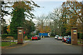
Leaving The Warren
The Warren is a loop of private road with very expensive houses. Beyond the pillar on the left is the entrance to Ashstead Hospital.
Image: © Robin Webster
Taken: 21 Nov 2011
0.21 miles