IMAGES TAKEN NEAR TO
Paddocks Way, ASHTEAD, KT21 2QY
Introduction
This page details the photographs taken nearby to Paddocks Way, KT21 2QY by members of the Geograph project.
The Geograph project started in 2005 with the aim of publishing, organising and preserving representative images for every square kilometre of Great Britain, Ireland and the Isle of Man.

There are currently over 7.5m images from over14,400 individuals and you can help contribute to the project by visiting https://www.geograph.org.uk
Image Map
Images are licensed for reuse under creativecommons.org/licenses/by-sa/2.0
Notes
- Clicking on the map will re-center to the selected point.
- The higher the marker number, the further away the image location is from the centre of the postcode.
Image Listing (17 Images Found)
Images are licensed for reuse under creativecommons.org/licenses/by-sa/2.0
Image
Details
Distance
1
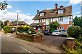
Alexander Lodge Care Home
Large Edwardian house in Skinners Lane, now a care home.
Image: © Ian Capper
Taken: 7 Sep 2018
0.11 miles
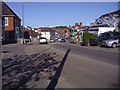
2
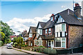
Skinners Lane
Edwardian villas in Skinners Lane.
Image: © Ian Capper
Taken: 7 Sep 2018
0.14 miles
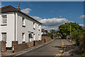
3
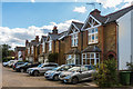
Maple Road
Edwardian semis off Ottways Lane.
Image: © Ian Capper
Taken: 7 Sep 2018
0.18 miles
4
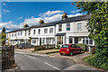
Skinners Lane
Turn of the 19th/20th Century terrace in Skinners Lane.
Image: © Ian Capper
Taken: 7 Sep 2018
0.18 miles
5
Ashtead town centre
Epsom Road looking from the west.
Image: © David Howard
Taken: 26 Apr 2009
0.18 miles
6
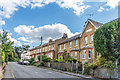
Skinners Lane
Edwardian terraced housing in Skinners Lane - the plaque on the near gable says "Pleasant Terrace 1904".
Image: © Ian Capper
Taken: 7 Sep 2018
0.20 miles
7
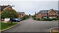
Bramley Grove
Housing infill development on a school site.
Image: © James Emmans
Taken: 4 Sep 2021
0.21 miles
8
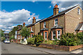
40 Ottways Lane
Late Victorian house in Ottways Lane.
Image: © Ian Capper
Taken: 7 Sep 2018
0.21 miles
9
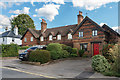
Grangemount Cottages
Mid 19th Century terrace in Ottways Lane.
Image: © Ian Capper
Taken: 7 Sep 2018
0.22 miles
10
Gladstone Road
Turn of the 19th/20th Century semi-detached cottages in a "T" shaped cul-de-sac off Skinners Lane.
Image: © Ian Capper
Taken: 7 Sep 2018
0.23 miles