IMAGES TAKEN NEAR TO
Glebe Road, ASHTEAD, KT21 2NT
Introduction
This page details the photographs taken nearby to Glebe Road, KT21 2NT by members of the Geograph project.
The Geograph project started in 2005 with the aim of publishing, organising and preserving representative images for every square kilometre of Great Britain, Ireland and the Isle of Man.

There are currently over 7.5m images from over14,400 individuals and you can help contribute to the project by visiting https://www.geograph.org.uk
Image Map
Images are licensed for reuse under creativecommons.org/licenses/by-sa/2.0
Notes
- Clicking on the map will re-center to the selected point.
- The higher the marker number, the further away the image location is from the centre of the postcode.
Image Listing (39 Images Found)
Images are licensed for reuse under creativecommons.org/licenses/by-sa/2.0
Image
Details
Distance
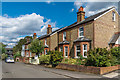
1

Glebe Road
c1950s extension to the original 1880s Glebe Road (see Image).
Image: © Ian Capper
Taken: 7 Sep 2018
0.01 miles
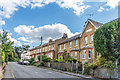
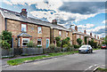
2
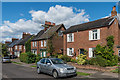
Glebe Road
A road of semi-detached cottages built in the 1880s by the Suburban Land and Cottage Company on former glebe land. The detached house on the right appears to have been built around the same time, being first shown along with the others on the 1895 1:2500 map - the difference may be explained by the 1877 1:2500 map showing a separate small parcel of land on the site where it was subsequently built.
Image: © Ian Capper
Taken: 7 Sep 2018
0.04 miles
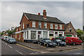
3
Ashtead Baptist Church
Baptist Church in Barnett Wood Lane, built in 1924 as Ashtead Free Church. Beyond are Woodman Cottages, dating from 1898.
Image: © Ian Capper
Taken: 20 Jul 2018
0.10 miles
4
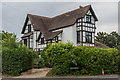
174 Barnett Wood Lane
House on the junction of Skinners Lane and Barnett Wood Lane. According to a 2017 estate agents particulars it was built in the 1880s and converted into 4 flats in 1932.
Image: © Ian Capper
Taken: 20 Jul 2018
0.10 miles
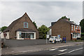
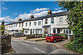
5
194 - 196 Barnett Wood Lane
Business on Barnett Wood Lane by its junction with Glebe Road. To its right is Ashtead Baptist Church.
Image: © Ian Capper
Taken: 20 Jul 2018
0.11 miles
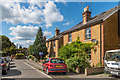
6
Gladstone Road
Turn of the 19th/20th Century semi-detached cottages in a "T" shaped cul-de-sac off Skinners Lane.
Image: © Ian Capper
Taken: 7 Sep 2018
0.11 miles
7
Skinners Lane
Edwardian terraced housing in Skinners Lane - the plaque on the near gable says "Pleasant Terrace 1904".
Image: © Ian Capper
Taken: 7 Sep 2018
0.12 miles
8
Skinners Lane
Turn of the 19th/20th Century terrace in Skinners Lane.
Image: © Ian Capper
Taken: 7 Sep 2018
0.12 miles
9
Gladstone Road
Turn of the 19th/20th Century semi-detached cottages in a "T" shaped cul-de-sac off Skinners Lane.
Image: © Ian Capper
Taken: 7 Sep 2018
0.13 miles
10
Gladstone Road
Turn of the 19th/20th Century semi-detached cottages in a "T" shaped cul-de-sac off Skinners Lane. The nearest building has a plaque "Graylands Cottages" while the building two along has one "Connaught Villas".
Image: © Ian Capper
Taken: 7 Sep 2018
0.13 miles