IMAGES TAKEN NEAR TO
Barnett Wood Lane, ASHTEAD, KT21 2LP
Introduction
This page details the photographs taken nearby to Barnett Wood Lane, KT21 2LP by members of the Geograph project.
The Geograph project started in 2005 with the aim of publishing, organising and preserving representative images for every square kilometre of Great Britain, Ireland and the Isle of Man.

There are currently over 7.5m images from over14,400 individuals and you can help contribute to the project by visiting https://www.geograph.org.uk
Image Map
Images are licensed for reuse under creativecommons.org/licenses/by-sa/2.0
Notes
- Clicking on the map will re-center to the selected point.
- The higher the marker number, the further away the image location is from the centre of the postcode.
Image Listing (47 Images Found)
Images are licensed for reuse under creativecommons.org/licenses/by-sa/2.0
Image
Details
Distance
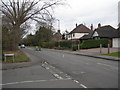
1
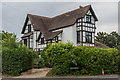
174 Barnett Wood Lane
House on the junction of Skinners Lane and Barnett Wood Lane. According to a 2017 estate agents particulars it was built in the 1880s and converted into 4 flats in 1932.
Image: © Ian Capper
Taken: 20 Jul 2018
0.03 miles
2
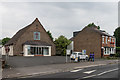
Ashtead Baptist Church
Baptist Church in Barnett Wood Lane, built in 1924 as Ashtead Free Church. Beyond are Woodman Cottages, dating from 1898.
Image: © Ian Capper
Taken: 20 Jul 2018
0.05 miles
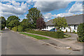
3
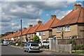
Taylor Road
c1920s housing off Barnett Wood Lane.
Image: © Ian Capper
Taken: 7 Sep 2018
0.06 miles
4
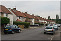
Taylor Road
c1920s housing in a cul-de-sac off Barnett Wood Lane.
Image: © Ian Capper
Taken: 20 Jul 2018
0.06 miles
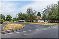
5
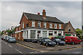
194 - 196 Barnett Wood Lane
Business on Barnett Wood Lane by its junction with Glebe Road. To its right is Ashtead Baptist Church.
Image: © Ian Capper
Taken: 20 Jul 2018
0.06 miles
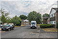
6
Green Lane
Housing on what was (as the name suggests) once a track, with development commencing around the 1960s.
Image: © Ian Capper
Taken: 7 Sep 2018
0.09 miles
7
Brooker's Close
Late 1950s former council housing off Green Lane, replacing an area of prefabs built in 1946 to provide mainly for ex-servicemen and war widows.
Image: © Ian Capper
Taken: 20 Jul 2018
0.09 miles
8
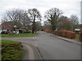
Green Lane, Ashtead
Near the junction of Oakhill Road, looking towards the pedestrian level crossing.
Image: © Danny P Robinson
Taken: 28 Jan 2007
0.10 miles
9
Barnett Wood Lane, Ashtead
At the junction of Green Lane.
Image: © Danny P Robinson
Taken: 28 Jan 2007
0.10 miles
10
Oakhill Road
1960s housing built on a road off Green Lane on the site of what was from the late 19th Century until 1909 Sparrow's brickworks and then a rose garden and nursery operated by nurseryman Henry Weller. As the name suggests, Green Lane itself was originally a track.
Image: © Ian Capper
Taken: 20 Jul 2018
0.12 miles