IMAGES TAKEN NEAR TO
Bushey Shaw, ASHTEAD, KT21 2HP
Introduction
This page details the photographs taken nearby to Bushey Shaw, KT21 2HP by members of the Geograph project.
The Geograph project started in 2005 with the aim of publishing, organising and preserving representative images for every square kilometre of Great Britain, Ireland and the Isle of Man.

There are currently over 7.5m images from over14,400 individuals and you can help contribute to the project by visiting https://www.geograph.org.uk
Image Map
Images are licensed for reuse under creativecommons.org/licenses/by-sa/2.0
Notes
- Clicking on the map will re-center to the selected point.
- The higher the marker number, the further away the image location is from the centre of the postcode.
Image Listing (11 Images Found)
Images are licensed for reuse under creativecommons.org/licenses/by-sa/2.0
Image
Details
Distance
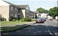
1
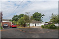
Bushey Shaw
c1960s housing in a cul-de-sac off Links Road, originally called Fairholme Close.
Image: © Ian Capper
Taken: 20 Jul 2018
0.03 miles
2
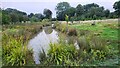
Rye Meadows Wetlands
Managed area next to the Rye Brook to improve wildlife and reduce flooding.
https://www.ryemeadows.org.uk/
Image: © James Emmans
Taken: 4 Sep 2021
0.07 miles
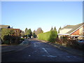
3
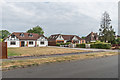
Links Road
Housing in a section of Links Road developed in the inter-War period of the 20th Century.
Image: © Ian Capper
Taken: 20 Jul 2018
0.10 miles
5
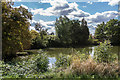
Floral Pool
Part of what was a flooded clay pit for what was from the late 19th Century until 1909 Sparrow's brickworks. It was subsequently developed into an outdoors swimming facility forming part of a rose garden and nursery operated by nurseryman Henry Weller (hence the name). This ceased in around the 1950s after which the area was developed for housing.
Image: © Ian Capper
Taken: 7 Sep 2018
0.21 miles
6
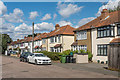
Caen Wood Road
c1930s semis on Caen Wood Road.
Image: © Ian Capper
Taken: 7 Sep 2018
0.22 miles
7
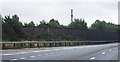
Telecommunications tower by the M25 near junction 9
Image: © N Chadwick
Taken: 23 Aug 2010
0.22 miles
9
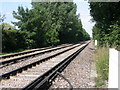
Railway to Leatherhead
Where a footpath crosses the railway between Leatherhead and Ashtead stations.
Image: © Ben Gamble
Taken: 9 Jul 2005
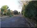
0.24 miles
10
Brookers Close
Brookers Close, Lower Ashtead
Image: © Ben Gamble
Taken: 9 Jul 2005
0.24 miles